Palisades Long Path
check with the trail manager for updated details before visiting.
Palisades Long Path
Nonprofit
Backcountry Trail
- Length
12 miles
- Elevation Gain
--
- Route Type
out & back
- Length
12 miles - Elevation Gain
-- - Route Type
out & back
Located within the Palisades Interstate Park, th New Jersey section of the Long Path begins at the George Washington Bridge, and ends at the New Jersey/New York state line. Yearly, thousands hike the Long Path for its many accessible Hudson River overlooks.

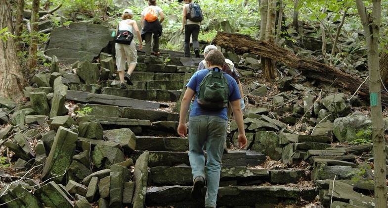
Hikers ascending stairs on the Long Path. Photo by Anthony Taranto.

Frog on Skunk Cabbage. One of many common sights from the Long Path. Photo by Anthony Taranto.

Park employees and NYNJTC volunteers carry a bridge stringer by the Womens Federation Monument. Photo by Anthony Taranto.
Location: Crestline trail from Fort Lee N to Alpine at top of Palisades.
- States: New Jersey
- Counties: Bergen
The 12-mile New Jersey section of the Long Path begins in Fort Lee just south of one of the busiest river crossings in the world, the George Washington Bridge, and ends at the New Jersey/New York state line. Yearly, thousands hike the Long Path for its many accessible Hudson River overlooks, the highest being State Line Lookout located in Alpine, NJ, 532 feet above river level. The Long Path is primarily maintained by the Palisades Interstate Park Commission, one of the earliest examples of interstate cooperation for land conservation in the country. Also responsible for maintenance is the New York/New Jersey Trail Conference, whose efforts help keep the trail passable year-round. Six trails connect to the Long Path, one being the Huyler Landing Trail, which General Lord Cornwallis' British Army used to scale the New Jersey Palisades on November 20th, 1776. Many in the area consider this trail special because it provides them with a place to get away from the hustle and bustle of the New York/New Jersey metropolitan area. The Long Path's terrain makes it a favorite for many off-road runners who fold it into part of their marathon-training regimen.
Accessibility Information
No text provided.
Allowed Uses:
Dogs, on leash Hiking/WalkingPublic Contact
Anthony TarantoP.O. Box 155
Alpine, NJ 7620
[email protected] • (201) 768-1360 ext. 10
www.njpalisades.org
Contact the trail manager for current maps and visiting details.
More Details
- Elevation (low): --
- Elevation (high): --
- Elevation (cumulative): --
- Part of a Trail System? No
- National Designations: The Palisades Interstate Park in which the New Jer
- Surface (primary): Soil
- Surfaces (additional): --
- Tread Width (average): 36"
- Tread Width (minimum): --
- Running length (minimum): --
- Tread Grade (average, percent): --
- Tread Grade (maximum):
- Running length (maximum): --
- Cross-slope (average, percent): --
- Cross-slope (maximum): --
- Running length (maximum): --
- Certified as an NRT
Jun 1, 1971

