Petroglyph Point
check with the trail manager for updated details before visiting.
Petroglyph Point
National Park Service
Backcountry Trail
- Length
2.4 miles
- Elevation Gain
--
- Route Type
Loop
- Length
2.4 miles - Elevation Gain
-- - Route Type
Loop
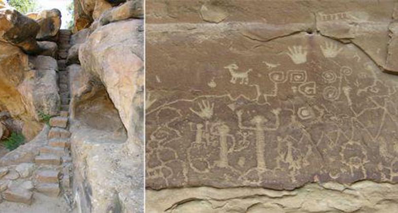
The trail winds south below the edge of Chapin Mesa and leads to the park's largest petroglyph panel, located 1.4 miles from the trailhead at Petroglyph Point. The total distance of the loop is 2.4 miles with an elevation change of 174 feet and takes about two to three hours.
Location: In Mesa Verde National Park, near the Chapin Mesa Archeological Museum.
- States: Colorado
- Counties: Montezuma
- Cities/Townships: Mesa Verde National Park
The trail winds south below the edge of Chapin Mesa and leads to the park's largest petroglyph panel, located 1.4 miles from the trailhead at Petroglyph Point. The total distance of the loop is 2.4 miles with an elevation change of 174 feet and takes about two to three hours.
This popular trail begins from the Spruce Tree House Trail and continues below the edge of Chapin Mesa to a large petroglyph panel. It then climbs to the top of the mesa and returns via the rim to the museum. The trail provides views of Spruce and Navajo Canyons and is the only trail in the park that offers views of petroglyphs.
This trail is unpaved and narrow in places, with drop-offs, uneven stone steps, and some scrambling required as you climb out of the canyon.
The trail is only open when Spruce Tree House is open to the public. When Spruce Tree House is closed, the gate to the Petroglyph Point trailhead is locked. Contact a ranger or check the park website at www.nps.gov/meve/planyourvisit/hours for times the trail is open. During the winter and spring, due to ice and snow, you may be directed to access the petroglyph panel via the mesa top section of the trail, or the entire trail may be closed. Ask the ranger at the Chapin Mesa Archeological Museum for trail conditions and to register for the hike.
For Your Safety:
- The trail is between 6,800 to 7,000 ft (2,073 to 2,134 m) in elevation.
- The Mesa Verde climate is dry and the summers can be hot. Hikers are advised to carry and drink plenty of water and to rest often.
- Remain on the trail and avoid walking along unstable cliff edges.
- Pets are not allowed on trails.
- Please register at either the trailhead or the museum. Trail guides are available in both locations.
Accessibility Information
No text provided.
Allowed Uses:
Hiking/WalkingOther Activities
- Heritage and history
- Wildlife viewing / observation
Public Contact
Carol SperlingMesa Verde National Park
PO Box 8
Mesa Verde, CO 81330
(970) 529-4628
www.nps.gov/meve/planyourvisit/hiking.htm
Contact the trail manager for current maps and visiting details.
More Details
- Elevation (low): --
- Elevation (high): --
- Elevation (cumulative): --
- Part of a Trail System? No
- Surface (primary): Soil
- Surfaces (additional): --
- Tread Width (average): 12"
- Tread Width (minimum): --
- Running length (minimum): --
- Tread Grade (average, percent): 3
- Tread Grade (maximum): 12
- Running length (maximum): --
- Cross-slope (average, percent): --
- Cross-slope (maximum): --
- Running length (maximum): --
- Certified as an NRT
Apr 12, 1982


