Piedra Blanca
check with the trail manager for updated details before visiting.
Piedra Blanca
USDA Forest Service
Backcountry Trail
- Length
18.2 miles
- Elevation Gain
--
- Route Type
out & back
- Length
18.2 miles - Elevation Gain
-- - Route Type
out & back
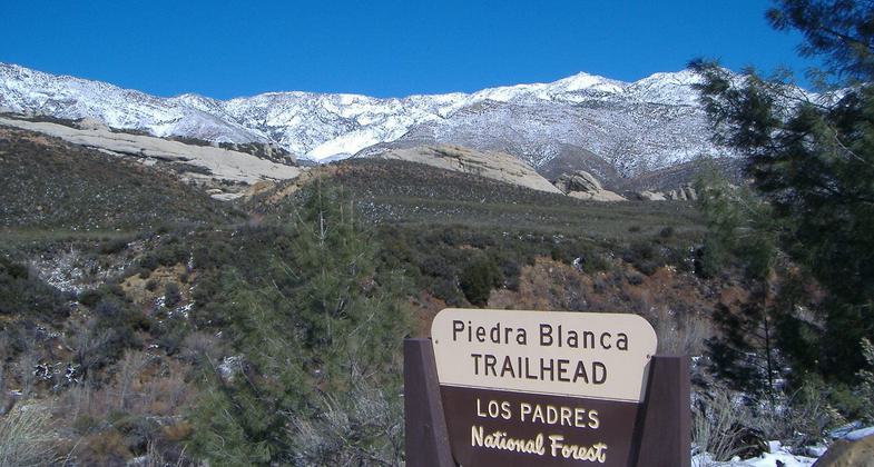
The trail climbs out of the Sespe River Gorge with views of the striking white sandstone formation. After winding into rugged chaparral-covered hills and along several perennial streams, crosses Pine Mountain ridge and down to campground with vistas of Cuyama.
Location: North of Ojai and south of Lockwood Valley in the Sespe Wilderness
- States: California
- Counties: Ventura
The trail climbs out of the Sespe River Gorge with views of the striking white sandstone formation. After winding into rugged chaparral-covered hills and along several perennial streams, crosses Pine Mountain ridge and down to campground with vistas of Cuyama.
From the Piedra Blanca Trailhead, the southern starting point, the trail crosses Lion Creek and the Sespe River. The trail continues north over impressive sandstone formations and then it follows along the Piedra Blanca Creek. After passing Piedra Blanca and Twin Forks Camps, the trail leaves the creek and climbs to Pine Mountain Lodge Camp. Traveling northwest, the trail passes Three Mile and Haddock Camps. Just beyond Haddock Camp, the trail enters the Mt. Pinos District, where it descends to Bear Creek and Upper Reyes Camps. Three miles beyond Upper Reyes Camp is the northern trailhead at Reyes Creek Campground.
Accessibility Information
No text provided.
Allowed Uses:
Dogs, on leash Hiking/WalkingOther Activities
- Camping
- Wildlife viewing / observation
Public Contact
Mt. Pinos Ranger District34580 Lockwood Valley Road
Frazier Park, CA 93225
(661) 245-1526
Contact the trail manager for current maps and visiting details.
More Details
- Elevation (low): 3060
- Elevation (high): 6000
- Elevation (cumulative): --
- Part of a Trail System? No
- Surface (primary): Soil
- Surfaces (additional): --
- Tread Width (average): 24"
- Tread Width (minimum): --
- Running length (minimum): --
- Tread Grade (average, percent): --
- Tread Grade (maximum):
- Running length (maximum): --
- Cross-slope (average, percent): --
- Cross-slope (maximum): --
- Running length (maximum): --
- Certified as an NRT
Dec 22, 1977


