Platte River Greenway Trail
check with the trail manager for updated details before visiting.
Platte River Greenway Trail
State
Frontcountry Trail
- Length
7 miles
- Elevation Gain
--
- Route Type
out & back
- Length
7 miles - Elevation Gain
-- - Route Type
out & back

Colorado underbrush along South Platte River Trail. Photo by Hagen Hammons.

photo by John M. Pflaum, P.E.
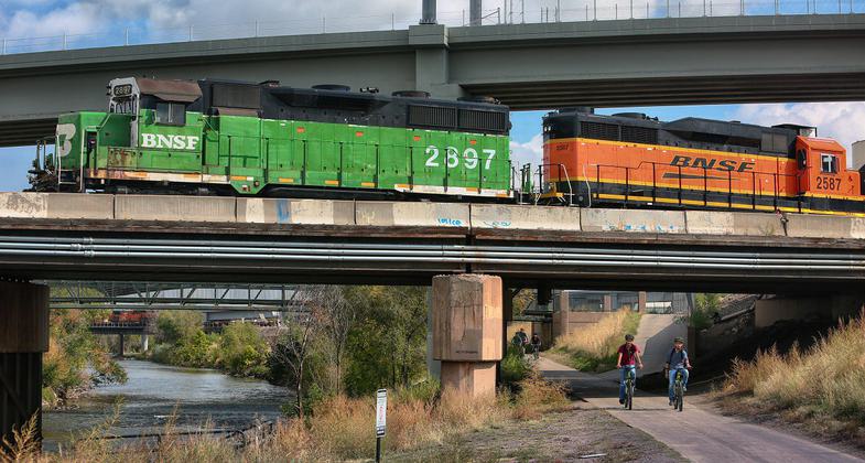
The trail passes under several active freight and passenger rail tracks that serve Denver. Photo by Scott Stark.

S. Platte River Greenway, along the South Suburban reach south of Denver, Colorado. Photo by John Pflaum.

S. Platte River Greenway, along the South Suburban reach south of Denver, Colorado. Photo by John Pflaum.

S. Platte River Greenway, along the South Suburban reach south of Denver, Colorado. Photo by John Pflaum.


Location: In downtown Denver from Interstate 70 to below Interstate 25 along Platte River.
- States: Colorado
The South Platte River Greenway Trail offers easy pedestrian and bike-friendly access to several city attractions including Invesco Field, Elich Gardens, the Children's Museum, and several city parks.
This 7-mile out-and-back covers a short stretch of the path between Denver's downtown REI and Valverde Park. But the paved pedestrian byway stretches 15 miles north to the border of Adams County and nearly 20 miles south to the Chatfield Reservoir, so there are plenty of options for lengthening your outing or exploring more of the city.
The riverside path is generally flat, wide, and smooth pavement with a few optional gravel sections.
Accessibility Information
No text provided.
Allowed Uses:
Bicycling Hiking/WalkingPublic Contact
Chad AndersonColorado State Parks
Trails Program
Denver, CO 80203
[email protected] • (303) 698-4903
Contact the trail manager for current maps and visiting details.
More Details
- Elevation (low): --
- Elevation (high): --
- Elevation (cumulative): --
- Part of a Trail System? No
- Surface (primary): --
- Surfaces (additional): --
- Tread Width (average): 0"
- Tread Width (minimum): --
- Running length (minimum): --
- Tread Grade (average, percent): --
- Tread Grade (maximum):
- Running length (maximum): --
- Cross-slope (average, percent): --
- Cross-slope (maximum): --
- Running length (maximum): --
- Certified as an NRT
Apr 24, 1978