Prairie Spirit Rail Trail State Park
check with the trail manager for updated details before visiting.
Prairie Spirit Rail Trail State Park
State
Rail Trail
- Length
51 miles
- Elevation Gain
--
- Route Type
out & back
- Length
51 miles - Elevation Gain
-- - Route Type
out & back
Kansas' first state-managed rail trail, Prairie Spirit Trail State Park gives users a 51-mile tour through tallgrass prairie, woodlands, agricultural fields, and eight small rural communities with country hospitality. The trail is eight feet wide, limestone screening surfaced except in Garnett, Iola, and Ottawa where it is asphalt. It connects with a network of trails including the Flint Hills Trail State Park (117 miles) and the Southwind Trail (9 miles).

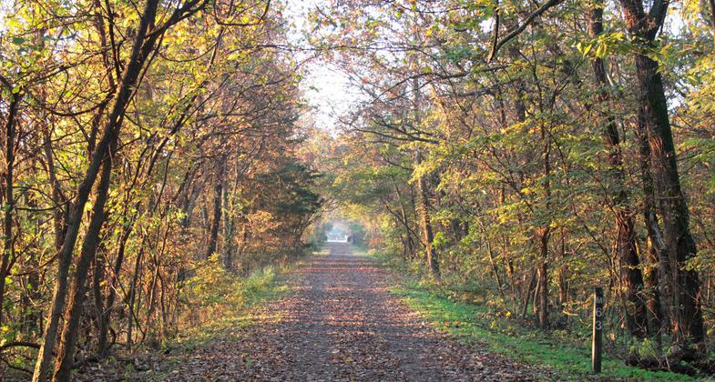
Prairie Spirit Trail in Fall. Photo by KDWPT staff

Photo

Photo

Photo

Photo

Photo

Photo

Photo
Location: Ottawa to Iola in Kansas
- States: Kansas
- Counties: Franklin, Anderson, Allen
- Cities/Townships: Ottawa, Garnett, Welda, Colony, Carlyle, Iola
Kansas' first state-managed rail trail, Prairie Spirit Trail State Park gives users a 51-mile tour through tallgrass prairie, woodlands, agricultural fields, and eight small rural communities with country hospitality. The trail is eight feet wide, limestone screening surfaced except in Garnett, Iola, and Ottawa where it is asphalt. It connects with a network of trails including the Flint Hills Trail State Park (117 miles) and the Southwind Trail (9 miles).
The Prairie Spirit Trail State Park pioneered rail-trail management in the state, overcoming considerable opposition, in the beginning, to become an important quality-of-life and health-benefit resource for the communities. The trail has provided an economic benefit, as well as being a valued community partner. In the early 90's when the trail began, some of the communities through which it passes were having economic difficulties. Thanks in part to the state's investment in the trail and local communities concentrating on quality-of-life development, the communities have seen positive growth. Several restaurants and bed and breakfasts have opened adjacent to the trail. A bicycle shop has a thriving business that includes ride services. Many community events focus on the trail and it hosts many races and other events annually, including the 50 and 100-mile ultra-marathon. Due to the intersection of the Prairie Spirit with the Flint Hills and Southwind trails, users of the Prairie Spirit trail have access to well over 150 miles of trail, with more trails connecting all the time.
The development of this network of trails has led to an explosion of communities wanting to continue their trails and connect them. It's the beginning of a network crisscrossing the State of Kansas and connecting to Nebraska and Missouri trails. Ultimately, these trails will be part of a nationwide network. Besides the interconnectivity, the trail is valuable as a local resource. Citizens of all ages use the trail for daily exercise and social interaction. Communities have sited play stations at intervals adjacent to the trail in their cities, encouraging exercise and play at the same time. Where the Prairie Spirit and Flint Hills trails intersect in Ottawa, Kansas, the community has raised funds for a $4 million investment in a community gathering place, with plans for farmer's markets and community concerts, with a restroom and showers to serve trail users. In Garnett, the trail connects a city park at the north end of town with one on the south end, both of which allow camping, and both have seen increased visitation due to the trail. Where the trail runs alongside the fairgrounds in Ottawa, it provides safe walking and cycling access for visitors.
The experience gained during the development of the Prairie Spirit Trail has equipped the Kansas Department of Wildlife, Parks and Tourism to better manage the development of the 117-mile Flint Hills Trail State Park. Prairie Spirit Trail started this ball rolling and the momentum continues to grow. From the beginning of the route prior to the Civil War to today, the trail route has provided a vital transportation and social corridor.
Accessibility Information
No text provided.
Allowed Uses:
Bicycling Dogs, on leash Hiking/Walking Snow, cross-country skiingOther Activities
- Fishing
- Heritage and history
- Snow, snow play general
- Wildlife viewing / observation
Public Contact
Trent McCownKansas Dept.of Wildlife, Parks and Tourism
419 S. Oak
Garnett, KS 66032
[email protected] • (785) 448-2627
Contact the trail manager for current maps and visiting details.
More Details
- Elevation (low): 863
- Elevation (high): 1148
- Elevation (cumulative): --
- Part of a Trail System? No
- State Designations: State Park
- Surface (primary): Rock, crushed
- Surfaces (additional): Paved
- Tread Width (average): 96"
- Tread Width (minimum): 96
- Running length (minimum): --
- Tread Grade (average, percent): 1
- Tread Grade (maximum): 5
- Running length (maximum): --
- Cross-slope (average, percent): 1
- Cross-slope (maximum): --
- Running length (maximum): --
- Certified as an NRT
Oct 23, 2020

