Prairie Winds Trail
This information is a public record of the 2005 NRT application and may be out of date if it has not been updated by a trail manager --
check with the trail manager for updated details before visiting.
check with the trail manager for updated details before visiting.
Prairie Winds Trail
U.S. Fish and Wildlife Service
Backcountry Trail
- Length
0.75 miles
- Elevation Gain
--
- Route Type
out & back
- Length
0.75 miles - Elevation Gain
-- - Route Type
out & back
The .75-mile Prairie Winds Trail travels through distinctive habitats including white-tailed deer, waterfowl, wading birds, and songbirds.

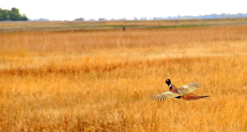
A rooster pheasant flushes and glides to heavier cover on Sand Lake NWR in South Dakota. Photo by USFWS.

Scenery and wildlife at Sand Lake National Wildlife Refuge in South Dakota. Photo by USFWS.

Landscape at Sand Lake National Wildlife Refuge. Photo by John and Karen Hollingsworth.
Location: Sand Lake National Wildlife Refuge, In Sand Lake NWR near Heda and Houghton north of Aberdeen.
- States: South Dakota
- Counties: Brown
The .75-mile Prairie Winds Trail travels through distinctive habitats including white-tailed deer, waterfowl, wading birds, and songbirds. The trail is partially accessible and includes interpretive kiosks, restrooms, parking, weather shelters, benches, and tables. The trail is of significant historical value in that it is the site of the first recorded Catholic Mass in the state of South Dakota in 1845.
Accessibility Information
No text provided.
Allowed Uses:
Dogs, on leash Hiking/WalkingPublic Contact
Gene WilliamsUSFWS, Sand Lake NWR
39650 Sand Lake Drive
Columbia, SD 57433
(605) 885-6320
Contact the trail manager for current maps and visiting details.
More Details
- Elevation (low): 1300
- Elevation (high): 1310
- Elevation (cumulative): --
- Part of a Trail System? No
- Surface (primary): Rock, crushed
- Surfaces (additional): Rock, crushed
- Tread Width (average): 46"
- Tread Width (minimum): --
- Running length (minimum): --
- Tread Grade (average, percent): 1
- Tread Grade (maximum): 2
- Running length (maximum): --
- Cross-slope (average, percent): --
- Cross-slope (maximum): --
- Running length (maximum): --
- Certified as an NRT
Jun 2, 2005

