Richard Martin Trail
check with the trail manager for updated details before visiting.
Richard Martin Trail
City, Town, or County
Rail Trail
Urban Trail
- Length
10.2 miles
- Elevation Gain
--
- Route Type
out & back
- Length
10.2 miles - Elevation Gain
-- - Route Type
out & back
Richard Martin led a 25-year effort with volunteers and various community organizations to establish a continuous 10.2-mile, rails-to-trails bicycle, equestrian, and pedestrian trail in Limestone County, Alabama. The Richard Martin Trail accesses outstanding natural, cultural, and historic resources. Natural features include beautiful wetlands and flora and fauna that are indigenous to the Tennessee Valley. A historic site on the trail marks the bloodiest Civil War battle on Alabama soil, the Battle of Sulphur Creek Trestle.

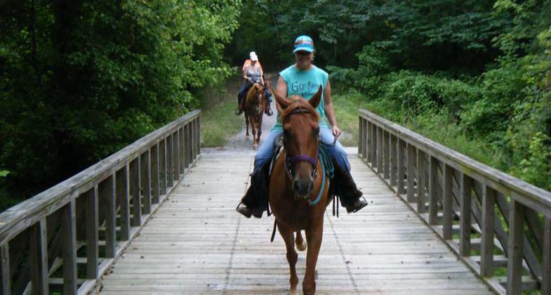
Horseback riders crossing bridge. Photo by Kari Kirby.

Elkmont Caboose. Photo by Rob Grant.

Riders near bridge abutments. Photo by Beth McCreless.

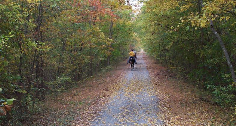
The beauty of fall colors. Photo by Beth McCreless.

Horse and Buggy Days. Photo by Beth McCreless.

Horses getting a drink below the covered bridge. Photo by Beth McCreless.

Covered bridge on the Richard Martin National Recreation Trail in Elkmont. Photo by Beth McCreless.

Restored 1800's community church. Photo by Beth McCreless.

Horseback riders and cyclist visit at a covered bridge. Photo by Kari Kirby.

Horses and hitching post. Photo by Kari Kirby.
Location: Piney Chapel to Veto, Alabama, Rail trail from Veto southwest of Veto Road through Elkmont to Piney Chapel Road.
- States: Alabama
- Counties: Limestone
Richard Martin led a 25-year effort with volunteers and various community organizations to establish a continuous 10.2-mile, rails-to-trails bicycle, equestrian, and pedestrian trail in Limestone County, Alabama. The Richard Martin Trail accesses outstanding natural, cultural, and historic resources. Natural features include beautiful wetlands and flora and fauna that are indigenous to the Tennessee Valley. A historic site on the trail marks the bloodiest Civil War battle on Alabama soil, the Battle of Sulphur Creek Trestle.
Throughout the construction of the Trail, the Boy Scouts of America have been involved. Eagle Scouts have done various projects to earn their badges.
Accesses outstanding natural, cultural, and/or historic resources: The Richard Martin Trail has beautiful natural wetlands that have numerous wildflowers such as wild azaleas, dogwoods, redbuds, violets, passion, and wild iris. A historical site on the Trail is where the bloodiest civil war battle on Alabama soil took place, the Battle of Sulphur Creek Trestle. There were a minimum of 200 men killed in battle on September 25, 1864. Most of the men killed were runaway slaves that had joined the Union Army.
Provides trail experiences for underserved communities: There are many events that take place all during the year that everyone, including underserved individuals, may participate in. In March we have Sassafras Tea Day. This is an early wildflower walk with a taste-testing treat of freshly brewed sassafras tea from sassafras trees on the Trail. In April, the dogwoods and redbuds are in full bloom. May has Horse and Buggy Day for all area equestrians. National Trail Day is the June event. In August the jewel weed is in full bloom and attracts hundreds of hummingbirds and butterflies. This is a joy for people of all ages. October brings beautiful fall colors. Although the Trail is a non-motorized trail, there is a Fall Walk and Ride each year at which time senior citizens are driven down the Trail in buses to enjoy the fall colors at their peak.
Accessibility Information
No text provided.
Allowed Uses:
Bicycling Dogs, on leash Equestrian Hiking/WalkingOther Activities
- Wildlife viewing / observation
Public Contact
Greater Limestone County Chamber of Commerce101 South Beaty Street
Athens, AL 35611
[email protected] • (256) 232-2600
ourathens.com
Contact the trail manager for current maps and visiting details.
More Details
- Elevation (low): 662
- Elevation (high): 831
- Elevation (cumulative): --
- Part of a Trail System? No
- Surface (primary): Rock, crushed
- Surfaces (additional): --
- Tread Width (average): 127"
- Tread Width (minimum): --
- Running length (minimum): --
- Tread Grade (average, percent): --
- Tread Grade (maximum): 3
- Running length (maximum): --
- Cross-slope (average, percent): --
- Cross-slope (maximum): --
- Running length (maximum): --
- Certified as an NRT
May 2, 2010


