River Mountains Loop Trail
check with the trail manager for updated details before visiting.
River Mountains Loop Trail
National Park Service
Backcountry Trail
- Length
34.5 miles
- Elevation Gain
--
- Route Type
Loop
- Length
34.5 miles - Elevation Gain
-- - Route Type
Loop
The River Mountains Loop Trail is a paved multiple use, multi-jurisdictional trail approximately 35 miles in length surrounding the River Mountains connecting Lake Mead National Recreation Area, Hoover Dam, Boulder City, Henderson, and the rest of the Las Vegas Valley.

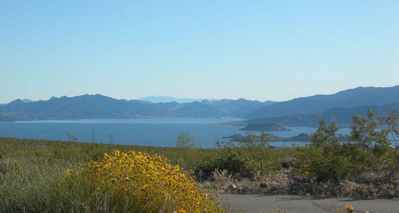
View of Lake Mead in the background.

Interpretive sign at trailhead near Alan Bible Visitor Center at Lake Mead. Photo by Sue.

Interpretive signage at Boulder City trailhead. Photo by Sue Crowe.

Trailhead signs at Boulder City trailhead. Photo by Sue Crowe.

New trail signage. Photo by Tony Taylor.

Old trail and new blacktop, with lake in the background showing mineral deposits after 15 years of drought. Photo by Tony Taylor.

Big Bike (metal) at the confluence of the RMLT and Bootleg Canyon International Mtn Bike area. Photo by Tony Taylor.
Location: The Trail encircles the mountains that separate the Las Vegas Valley and Lake Mead National Recreation Area. Connects Lake Mead NRA to east side of Henderson, circling the River Mountains.
- States: Nevada
- Counties: Clark
The River Mountains Loop Trail is a paved multiple use, multi-jurisdictional trail approximately 35 miles in length surrounding the River Mountains connecting Lake Mead National Recreation Area, Hoover Dam, Boulder City, Henderson, and the rest of the Las Vegas Valley.
The trail is completely separate and isolated from the highway system allowing families to use the trail without fear of hiking or bicycling in traffic. The alternative transportation corridor to the existing highway system was an important element in the design of this trail. Portions of the trail (15 miles) include a parallel equestrian trail, providing a designated path between the Las Vegas Valley and the backcountry of Lake Mead National Recreation Area.
Most of this trail is constructed in rural areas, providing opportunities to connect with the natural desert setting. The River Mountains support one of the largest bighorn sheep populations in the area and the perimeter trail provides great opportunities to view bighorn sheep in their natural setting. In addition, the River Mountains provide habitat for the threatened desert tortoise, a species seldom seen as it resides in desert settings and is only active in the warmer months. The sighting of these special species makes the daily sighting of jackrabbits, coyotes, bluebirds, lizards, and many other animals go relatively unappreciated.
The vistas along the trail are outstanding. The River Mountains form the scenic backdrop for the community of Henderson, Nevada, along the eastern side of the Las Vegas Valley. The maintenance of this view from the valley is valued and has been recognized in local and regional open space planning. But the views from the trail are also outstanding and include panoramas of the Las Vegas Wash, Lake Mead, Hemenway Valley, and Eldorado Valley, and perhaps the most spectacular view is the view of the Las Vegas Valley.
The Clark County Health Department has been a fundamental supporter of all trail development and especially the River Mountains Loop Trail. At each of our events held in support of trail development, the Clark County Health Department has been an active participant in promoting health and fitness through trail use. The River Mountains Trail Partnership has worked closely with the Clark County Health Department in the promotion of the trail.
Accessibility Information
No text provided.
Allowed Uses:
Bicycling Hiking/WalkingOther Activities
- Camping
Public Contact
Roger HallCity of Boulder City
PO Box 61350
Boulder City, NV 89006
[email protected] • (702) 293-9255
Contact the trail manager for current maps and visiting details.
More Details
- Elevation (low): 1341
- Elevation (high): 2694
- Elevation (cumulative): --
- Part of a Trail System? No
- Surface (primary): Paved
- Surfaces (additional): --
- Tread Width (average): 127"
- Tread Width (minimum): --
- Running length (minimum): --
- Tread Grade (average, percent): --
- Tread Grade (maximum): 15
- Running length (maximum): --
- Cross-slope (average, percent): --
- Cross-slope (maximum): --
- Running length (maximum): --
- Certified as an NRT
May 2, 2010

