River Trail
check with the trail manager for updated details before visiting.
River Trail
National Park Service
Backcountry Trail
- Length
3 miles
- Elevation Gain
--
- Route Type
out & back
(1 review)
- Length
3 miles - Elevation Gain
-- - Route Type
out & back
The River Trail runs along the north side of the Schuylkill River at Valley Forge National Historical Park.

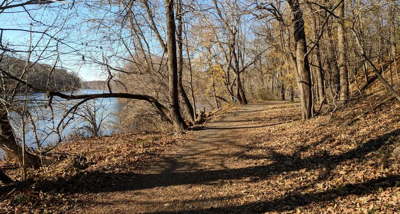
River Trail at Valley Forge NHP - 11-28-2017. Photo by Jim Walla.
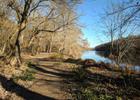
River Trail at Valley Forge NHP - near the Betzwood picnic area - 11-28-2017. Photo by Jim Walla.
Location: At Valley Forge NHS along N bank of Schuylkill River
- States: Pennsylvania
The River Trail runs along the north side of the Schuylkill River at Valley Forge National Historical Park (most of the park is south of the river). It is an out-and-back trail with a dirt parking lot on the west side at Pawlings Road and a paved parking lot on the east side at Sullivan’s Lane. The trail is open to hikers, bikers, and horseback riders. It is gravel and dirt, so don’t try to ride a road bike on it. The River Trail itself is nearly flat, so it is an easy hike or bike ride.
While the River Trail follows the Schuylkill River, clear views are rare due to vegetation between the trail and the water. There are a few clearings, and in some spots, people have made side trails down to the riverbank. However, the trail follows a ridge high above the river, so you’ll have to scurry down a hill to get to the water.
Two miles into the hike is a stone memorial that marks the site of a bridge built by General John Sullivan’s men during the Continental Army’s 1777-78 winter encampment at Valley Forge. The bridge was destroyed by flood waters the next year. A modern pedestrian bridge over the Schuylkill River on the east side of Valley Forge National Historical Park is named for Sullivan, as is the aforementioned Sullivan’s Lane. If you look behind the marker, you will see a trail heading north that connects to the Schuylkill River Trail.
There are a number of side trails that branch off from the River Trail. Three are shown on the Valley Forge National Historical Park trail map: east and west trailheads for the Commissary Trail and the above-mentioned connector to the Schuylkill River Trail at the Sullivan’s Bridge marker. However, none are identified with signage, so unless you have a GPS or are very familiar with the area, there’s really no way to know which is which.
Accessibility Information
No text provided.
Reviews
Jim Walla
River Trail at Valley Forge NHP
River Trail is a flat, well maintained trail that follows the Schuylkill River in Valley Forge National Historical Park. You will get very nice river views the whole length of the trail. The trail is out and back, but I took the park's Commissary and Schuylkill River Trails most of the way back to provide some variety. Having said that, the River Trail has much nicer views, so out and back is not a bad thing. Very pleasant, easy trail. Definitely worth your time.
Allowed Uses:
Hiking/WalkingPublic Contact
Valley Forge National Historic ParkValley Forge, PA 19482
Contact the trail manager for current maps and visiting details.
More Details
- Elevation (low): --
- Elevation (high): --
- Elevation (cumulative): --
- Part of a Trail System? No
- Surface (primary): --
- Surfaces (additional): --
- Tread Width (average): 0"
- Tread Width (minimum): --
- Running length (minimum): --
- Tread Grade (average, percent): --
- Tread Grade (maximum):
- Running length (maximum): --
- Cross-slope (average, percent): --
- Cross-slope (maximum): --
- Running length (maximum): --
- Certified as an NRT
Nov 18, 1981