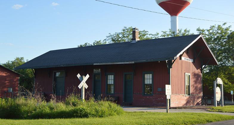
Rock Island State Trail
check with the trail manager for updated details before visiting.
Rock Island State Trail
- Length
27 miles - Elevation Gain
-- - Route Type
out & back
The Rock Island State Trail, named after the abandoned Rock Island Railroad line it races, is a 27-mile hiking-biking trail between Alta and Toulon, northwest of Peoria, Illinois.
Location: NW of Peoria, IL
- States: Illinois
- Counties: Peoria, Stark
The Rock Island State Trail, named after the abandoned Rock Island Railroad line it races, is a 27-mile hiking-biking trail between Alta and Toulon, northwest of Peoria, Illinois. The Trail corridor, generally 50-100 feet wide is a natural ribbon in central Illinois farmland, tree-canopied, with wildflowers and prairie grasses. The Trail includes several trestle bridges: one spanning the Spoon River, well known from Edgar Lee Masters' Spoon River Anthology.
The Peoria and Rock Island Railroad Co. was granted a charter to construct a railroad between Peoria and Rock Island on March 7, 1867. Construction began two years later, and the first regularly scheduled passenger train passed over the Rock Island line on July 8, 1871. For more than 40 years, passenger and freight trains used the line, but by 1915, rail traffic began to decline and ceased completely by the late 1950s.
Thanks to the foresight of Peoria's Forest Park Foundation, the abandoned railroad right-of-way was acquired in 1965 and donated to the State of Illinois four years later. Early attempts to develop and open the corridor as a trail were met with considerable opposition, especially from adjacent landowners. Fortunately, the concerns of all interests, including adjacent landowners, were addressed and today, the Trail is a popular attraction and many former opponents are now supporters of the Trail.
The trail corridor is well-vegetated, with trees, prairie grasses, and wildflowers. The Trail is within the Grand Prairie Division, a vast plain formerly covered with tall grass prairie. As the Trail has reverted to nature, much of the prairie has returned. North of Princeville is a dedicated State Nature Preserve. At Kickapoo Creek Recreation Area, 14 acres have been restored to native prairie.
The trail surface is crushed limestone. Trestle bridges cross several streams and the Spoon River made famous in Edgar Lee Masters' Spoon River Anthology. In Wyoming, a visitor center/museum and site office is in the restored Wyoming, Chicago, Burlington & Quincy Railroad Depot.
The Trail is primarily a hiking-biking trail. Visitor facilities include parking, toilets, and primitive campground in the Kickapoo Creek Recreation Area, with toilets, fire pads, picnic tables, water and a picnic shelter.
Accessibility Information
No text provided.
Allowed Uses:
Hiking/WalkingPublic Contact
Jason BeverlinIL Dept.of Natural Resources
311 E. Williams St., Box 64
Wyoming, IL 61491
(309) 695-2228
Contact the trail manager for current maps and visiting details.
More Details
- Elevation (low): 640
- Elevation (high): 800
- Elevation (cumulative): --
- Part of a Trail System? No
- State Designations: State Trail
- Surface (primary): Rock, crushed
- Surfaces (additional): Rock, crushed
- Tread Width (average): 102"
- Tread Width (minimum): --
- Running length (minimum): --
- Tread Grade (average, percent): 1
- Tread Grade (maximum): 3
- Running length (maximum): --
- Cross-slope (average, percent): --
- Cross-slope (maximum): --
- Running length (maximum): --
- Certified as an NRT
Jun 4, 2003


