Samuel Justus Trail
check with the trail manager for updated details before visiting.
Samuel Justus Trail
City, Town, or County
Rail Trail
- Length
8 miles
- Elevation Gain
--
- Route Type
out & back
- Length
8 miles - Elevation Gain
-- - Route Type
out & back
The Samuel Justus Trail is one of several that highlight the Allegheny River Region in Venango County, Pennsylvania.

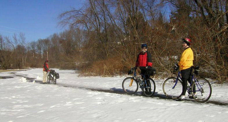
"Winter in Oil City" - Photograph copyright © 2007 by Mary Shaw.

Samuel Justus Trail
Location: Cranberry Township
- States: Pennsylvania
- Counties: Venango
The Samuel Justus Trail is one of several that highlight the Allegheny River Region in Venango County, Pennsylvania. This trail converted an abandoned railroad grade into an easily accessible walking/hiking trail with marvelous views. The trail draws walkers and bikers from several states and a few countries. This trail is a partnership of trails that extend north, south, east, and west and is in a constant state of expansion. The trail is nearly level with easy access for walkers and bikers of all levels of experience. A broad base of population is served - two cities, one borough, and several townships and villages. There are no costs to use the trail therefore persons of all income levels have ready access. A nonprofit group, The Allegheny Valley Trail Association, with many hours of volunteer time, provides management of the trail. Two tunnels and several bridges add to the beauty and uniqueness of this trail system. The trail system of which the Samuel Justus Trail is a part provides an outstanding natural and cultural experience for its users and runs through areas protected by the Wild and Scenic Rivers Act.
Accessibility Information
No text provided.
Allowed Uses:
Bicycling Dogs, on leash Equestrian Hiking/WalkingOther Activities
- Camping
- Fishing
Public Contact
Terry RayThe Township of Cranberry
3726 State Route 257
Seneca, PA 16346
[email protected] • (814) 676-8812
Contact the trail manager for current maps and visiting details.
More Details
- Elevation (low): 980
- Elevation (high): 1010
- Elevation (cumulative): --
- Part of a Trail System? No
- Surface (primary): Paved
- Surfaces (additional): Paved
- Tread Width (average): 96"
- Tread Width (minimum): --
- Running length (minimum): --
- Tread Grade (average, percent): 1
- Tread Grade (maximum): 1
- Running length (maximum): --
- Cross-slope (average, percent): --
- Cross-slope (maximum): --
- Running length (maximum): --
- Certified as an NRT
n/a

