Sauk Rail Trail
check with the trail manager for updated details before visiting.
Sauk Rail Trail
City, Town, or County
Frontcountry Trail
Rail Trail
- Length
33 miles
- Elevation Gain
--
- Route Type
out & back
- Length
33 miles - Elevation Gain
-- - Route Type
out & back
This trail was the first multi-purpose route in Iowa to boast two State Parks as its endpoints and another conservation area right in the middle.

Location: Lakeview to Carroll, Railtrail connects Carroll to Black Hawk Lake State Park in Sac and Carroll Counties.
- States: Iowa
- Counties: Sac, Carroll
- Cities/Townships: Carnarvon, Breda, Maple River, Lake View, Carroll
The Sauk Rail Trail set the standard by displaying the ability of rail trails to be much more than the proverbial "beaten path." This trail was the first multi-purpose route in Iowa to boast two State Parks as its endpoints and another conservation area right in the middle. The Sauk Rail Trail is truly helping Carroll and Sac Counties develop a strong greenbelt.
The 33-mile Sauk Rail Trail was completed in 1998. The charge was led by county conservation boards. A 13-mile midsection of the trail from Maple River to Carnarvon follows a former railbed. The north end of the trail encircles Black Hawk State Park and the southern part of the trail winds through the community of Carroll around Swan Lake State Park.
The Sauk Rail Trail is asphalt from Swan Lake State Park (the southernmost point) to Maple River Junction. It becomes crushed limestone from Maple River Junction to Carnarvon and finishes as concrete from Carnarvon to Lake View - Black Hawk State Park (northernmost point). The trail surface and minimal grade allow for a variety of uses. Cycling, walking, running, snowshoeing, cross-country skiing, and in-line skating are a few examples of what families and other visitors may enjoy.
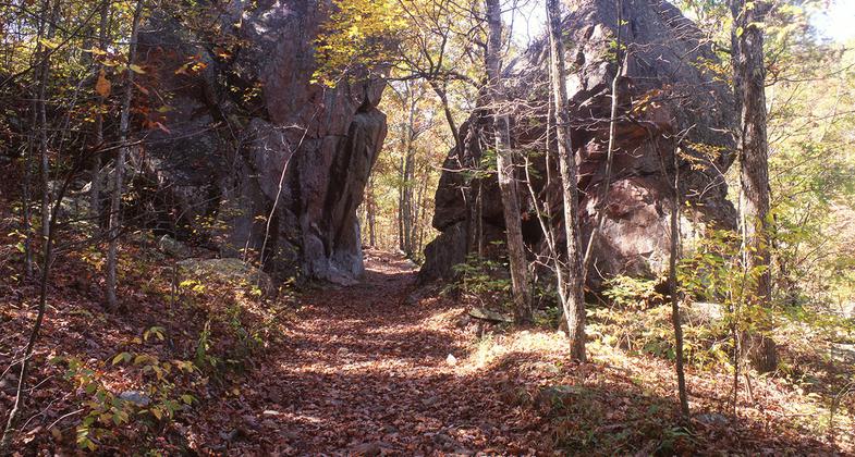
The Sauk Rail Trail meanders through Carroll and Sac Counties exposing users to an assortment of Midwest landscapes including rolling prairies, wetlands, farmland, and wooded areas. Hazelbrush Wildlife Area, the midpoint of the trail, offers a spectacular opportunity for wildlife observation and photography. This conservation area is approximately 80 acres and includes wetlands, timber, and meadows.
In addition to connecting three important recreation and conservation areas, the Sauk Rail Trail also connects several communities. Carnarvon, Breda, Maple River Junction, Lake View, and Carroll are all strung together by the trail. Together these towns offer many amenities and cultural and historical attractions.
Accessibility Information
No text provided.
Allowed Uses:
Bicycling Dogs, on leash Hiking/Walking Motorized vehicles, snowmobiling Snow, cross-country skiingOther Activities
- Snow, snow play general
Public Contact
Chris BassCarroll and Sac County Conservation
2970 280th St.
Sac City, IA 50583
(712) 792-8078
Contact the trail manager for current maps and visiting details.
More Details
- Elevation (low): 1200
- Elevation (high): 1382
- Elevation (cumulative): --
- Part of a Trail System? No
- Surface (primary): Paved
- Surfaces (additional): Rock, crushed
- Tread Width (average): 0"
- Tread Width (minimum): --
- Running length (minimum): --
- Tread Grade (average, percent): --
- Tread Grade (maximum):
- Running length (maximum): --
- Cross-slope (average, percent): --
- Cross-slope (maximum): --
- Running length (maximum): --
- Certified as an NRT
May 31, 2007