Scenic Loop Trail System at Staunton State Park
check with the trail manager for updated details before visiting.
Scenic Loop Trail System at Staunton State Park
State
Backcountry Trail
Urban Trail
- Length
18.8 miles
- Elevation Gain
--
- Route Type
Loop
- Length
18.8 miles - Elevation Gain
-- - Route Type
Loop
The Staunton State Park Loop Trail System is an 18.8-mile loop that will give visitors a glimpse of everything Colorado has to offer. From expansive views of sprawling meadows to mountain vistas to diverse wildlife the Staunton State Park Scenic Loop Trail System is a true gem of Colorado.
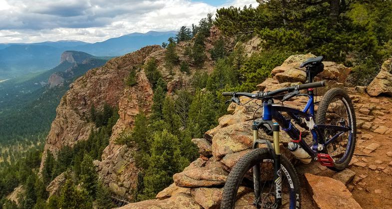
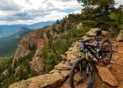
Catamount Overlook. Photo by Dale Specht

Trackchair program participant testing out a new course. Photo by Dale Specht.

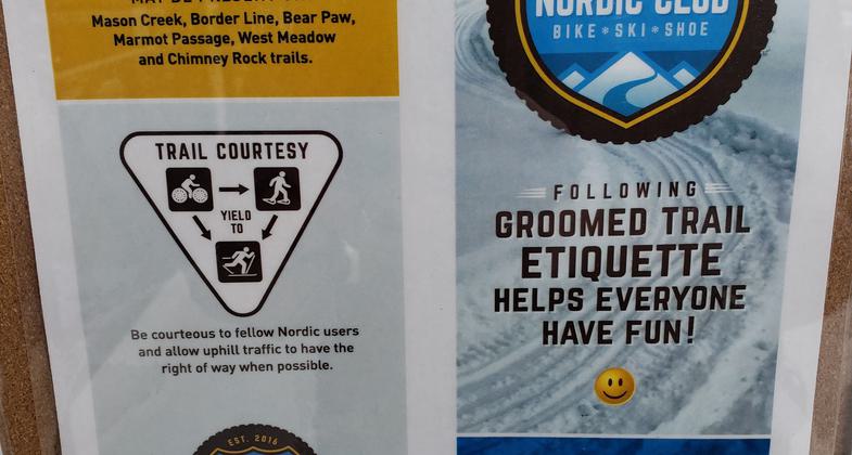
This photo is of the signage posted on the trailhead kiosk that explains trail etiquette for the winter months when snow is present on the trails.

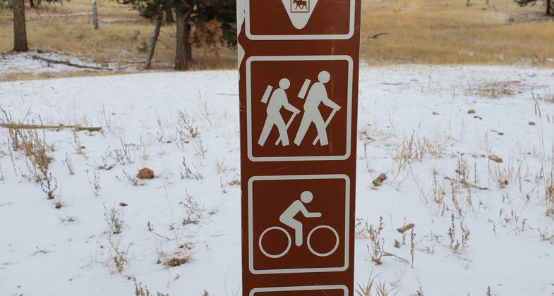
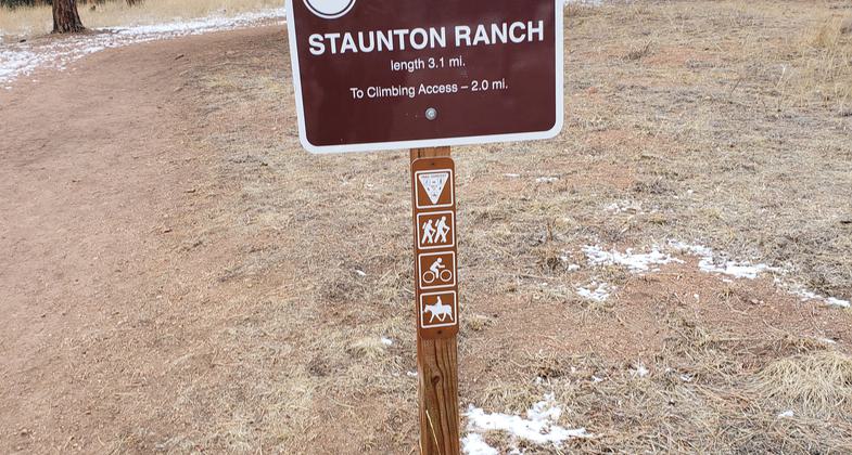
Each trail sign in Staunton State Park is accompanied with a smaller sign that states what trail user has the right-of-way as well as what user groups are permitted on the trail.

This is an example of the signage throughout Staunton State Park. Each sign lists the trail's name and length of the trail.

Photo of the Trackchair in use at Staunton State Park with a visitor
Location: The trailhead is located in Staunton State Park near Pine, Colorado approximately 45 minutes Southwest of Denver.
- States: Colorado
- Counties: Jefferson, Park
- Cities/Townships: Pine
The Staunton State Park Scenic Loop Trail System is a moderate in difficulty fitness trail loop located in Staunton State Park. Staunton State Park is located approximately 45 minutes southwest of the city of Denver. The Scenic Loop Trail System is commonly known as the "Staunton Big Loop" and is done by linking together several different trails to create an 18.8-mile loop to highlight some of the best features of Staunton State Park. This is quickly becoming a very popular route that is used by trail runners, hikers, bikers, and horseback riders. Due to the route's popularity, our entrance staff has taken hundreds of maps and highlighted the routes for visitors who are asking which trails make up the Staunton State Park Scenic Loop Trail System.
The application for the National Recreation Trail Designation of the Staunton State Park Scenic Loop Trail System is focused on the 18.8-mile route which highlights the best attributes of Staunton State Park. The park has a total of 27 miles, but the application focuses on the multi-use trails which are used to complete the Staunton State Park Scenic Loop Trail System which is growing in popularity.
Some of the highlights of the scenic loop trail system are Elk Falls (100' year-round waterfall), Chimney Rock (175' rock spire), five separate scenic overlooks, an interpretive site at an old mill, and several historic structures that are located along the trail. All historic buildings located in the park have interpretive signage designated to educate about Staunton State Park's history.
Staunton State Park has only been open to the public since 2013 and has continually provided improvements to the trails within the park creating new trails to make the trail loop what it is today. Since the park's first developments, we have made efforts to construct trails that allow users to create loops in hopes to alleviate user conflicts and give the user the option of longer trips with new scenery. Alleviating user conflicts on trails is done by giving the availability to link different to reduce the concentration of visitors on certain trails and spread out users throughout the park to help with overcrowding.
The design and construction of the scenic loop trail system were built around the premise of maximizing the user experience. With careful mapping and trail layout, the neighborhoods surrounding the park to the east and west are hidden from view so the users have a true nature experience! Buildings, roads, and parking lot size and placement are taken into consideration prior to construction so the views from overlooks and trails do not become polluted with views of man-made infrastructure. With the popularity of the trails in the last five years we have been able to host several races throughout the year for runners and mountain bikers. We have also partnered with a local Nordic club to groom trails in the winter with a two large diameter wheel drive motorbike, a Rokon, to create a smooth path for snowshoes, fat bikes, and cross-country skiers. This winter will be the first year we will enact this program in hopes to enhance the winter user experience.
Maintenance for all 18.8 miles has involved assistance on numerous fronts. To alleviate the cost of trail maintenance the park has implemented a volunteer trail team that undertakes routine maintenance as well as special projects on problem areas that improve the trails before issues become evident. Staunton State Park has also utilized several youth organizations such as Urban Rangers, Environmental Learning Kids, Boy Scouts, and different Youth Corps teams. The park has worked closely with local bike shops, Colorado Mountain Biking Association, and other not-for-profit user groups for project days to enhance the trail loop for all users. The park partners with the local high school mountain biking team that uses the trails for practice and in return they help with trail maintenance projects. Materials for trail projects on the park have been fueled and funded by our not-for-profit Friends of Staunton State Park and local business donations. Staunton State Park has partnered with the Colorado Forest Service, local fire departments, and park volunteers to thin the unhealthy sections of forest to increase the forest's biodiversity and help with wildfire mitigation along the trail loop. The thinning of the forest has allowed for diversity in wildlife that is seen from the trail and allowed for large aspen groves to flourish.
In 2017 Staunton State Park implemented a pilot program that raises the bar for accessibility in recreation. The program is free to the public on a reservation-based system that utilizes trackchairs (off-pavement motorized wheelchairs with rubber tracks) to allow visitors with mobility issues to go on a hike, some for the first time ever, with their family off of a paved path. There are certain 1-2 mile designated routes that the trackchairs utilize along the Staunton State Park Scenic Loop Trail System. Donations and public support of the trackchair program have allowed us to fund the purchase of more trackchairs and materials to keep the trails well-maintained on the designated routes.
The park has begun a trail etiquette effort to mitigate user conflict on the trails through signage, education, and a pilot program for loaning out bells for mountain bikes. All intersections are well marked with an emphasis on not over polluting the trails with signage.
The most popular route for the Staunton State Park Scenic Loop Trail System starts at the Mason Creek Parking Lot. The trip order is as follows: Dines Meadow Trail>Staunton Ranch Trail>Marmot Passage Trail>West Meadow Trail>Chimney Rock Trail>Border Line Trail>Mason Creek>Trail-Bear Paw Trail>Mason Creek Trail.
As an added bonus, recently the Staunton State Park Trail System gives access to a connector trail that connects two different communities. From the scenic loop trail system visitors are able to access the newly installed North Elk Creek/Cub Creek Trail from the Bugling Elk Trail which connects the communities of Evergreen, CO to Pine, CO through the Pike National Forest. The North Elk Creek Trail was constructed due to a large push in legislation from Colorado's Governor John Hickenlooper. The North Elk Creek Trail is not part of the Scenic Trail Loop System but should be recognized because it can be directly accessed from the park.
The entire trip offers everything that's great about Colorado and truly is a gem of Colorado!
Accessibility Information
No text provided.
Allowed Uses:
Bicycling Dogs, on leash Equestrian Hiking/Walking Snow, cross-country skiing Snow, snowshoeingOther Activities
- Fishing
- Heritage and history
- Rock climbing
- Snow, snow play general
- Wildlife viewing / observation
Public Contact
Zach TaylorColorado Parks and Wildlife
11559 Upper Ranch Dr.
Pine, CO 80470
[email protected] • 303-816-0912
Contact the trail manager for current maps and visiting details.
More Details
- Elevation (low): 8200
- Elevation (high): 9500
- Elevation (cumulative): --
- Part of a Trail System? No
- Surface (primary): Rock, crushed
- Surfaces (additional): Boardwalk, Rock, crushed, Rock, smooth, Sand, Snow or ice, Soil
- Tread Width (average): 30"
- Tread Width (minimum): 30
- Running length (minimum): --
- Tread Grade (average, percent): 105
- Tread Grade (maximum): 8
- Running length (maximum): --
- Cross-slope (average, percent): 20
- Cross-slope (maximum): --
- Running length (maximum): --
- Certified as an NRT
Oct 23, 2020