Schuylkill Trail at Schuylkill Banks
check with the trail manager for updated details before visiting.
Schuylkill Trail at Schuylkill Banks
Private
Frontcountry Trail
Urban Trail
- Length
1.2 miles
- Elevation Gain
--
- Route Type
out & back
- Length
1.2 miles - Elevation Gain
-- - Route Type
out & back
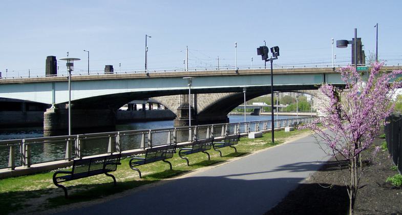
The Schuylkill Trail at Schuylkill Banks is a multi-use recreational trail extending along the east bank of the Schuylkill from Fairmount Water Works, a national historic site, to Locust Street in the city of Philadelphia.

The Schuylkill River Trail, a multi-use landscape trail built as part of the Schuylkill Banks improvement project. Photo by Jeffrey M. Vinocur.

Winner 2022 NRT Photo Contest, Urban Trails and Greenways. Photo by Lane Fike.

The trail is illuminated in the evenings to provide extended hours for users to enjoy the trail. Photo by Lane Fike.

Schuylkill River Falls at the Fairmount Dam opposite the Fairmount Water Works. Photo by michaelwm25.
Location: East side of the Schuylkill River between Fairmount Water Works and Locust Street
- States: Pennsylvania
- Counties: Philadelphia
The Schuylkill Trail at Schuylkill Banks is a multi-use recreational trail extending along the east bank of the Schuylkill from Fairmount Water Works, a national historic site, to Locust Street in the city of Philadelphia. The trail lies within a greenway of variable width (20 feet to 120 feet) and provides access to the Schuylkill River and riverbank along a section of the river that had been previously inaccessible.
The Schuylkill Trail at Schuylkill Banks is an urban trail paralleling the active tracks of the CSX Railroad. It is located adjacent to the Logan Square and Fitler Square neighborhoods, which form a portion of the Center City Philadelphia. The trail, approximately 1.2 miles in length, has become heavily used with an average of 14,000 user trips per week (a user trip is one person passing a cordon line in either direction). It accommodates workers, runners, bicyclists, in-line skaters, commuters, and people heading for a destination or event at or along the greenway (concert, movie, kayak tour, riverboat cruise, etc.).
The greenway includes suitable park furniture (benches, trash receptacles, etc.) and is planted with a well-designed palette of trees, shrubs, and ground cover.
The greenway and trail are a part of the Fairmount Park System and are managed by the Schuylkill River Development Corporation, a non-profit corporation whose mission is to revitalize the tidal Schuylkill River.
Accessibility Information
No text provided.
Allowed Uses:
Bicycling Boating, motorized Boating, human-powered Dogs, on leash Hiking/WalkingOther Activities
- Fishing
Public Contact
Joseph SyrnickSchuylkill River Development Corporation
2929 Arch Street, 13th Floor
Philadelphia, PA 19104
(215) 222-6032 ext. 10
Contact the trail manager for current maps and visiting details.
More Details
- Elevation (low): 4
- Elevation (high): 126
- Elevation (cumulative): --
- Part of a Trail System? No
- Surface (primary): Paved
- Surfaces (additional): Paved
- Tread Width (average): 127"
- Tread Width (minimum): --
- Running length (minimum): --
- Tread Grade (average, percent): 2
- Tread Grade (maximum): 5
- Running length (maximum): --
- Cross-slope (average, percent): --
- Cross-slope (maximum): --
- Running length (maximum): --
- Certified as an NRT
May 31, 2007

