Seminole Wekiva Trail
check with the trail manager for updated details before visiting.
Seminole Wekiva Trail
City, Town, or County
Backcountry Trail
Frontcountry Trail
Rail Trail
Urban Trail
- Length
14 miles
- Elevation Gain
--
- Route Type
out & back
- Length
14 miles - Elevation Gain
-- - Route Type
out & back
The diverse Seminole Wekiva Trail begins at the San Sebastian Trailhead in Altamonte Springs and continues approximately 14 miles, ending at the Wekiva River.

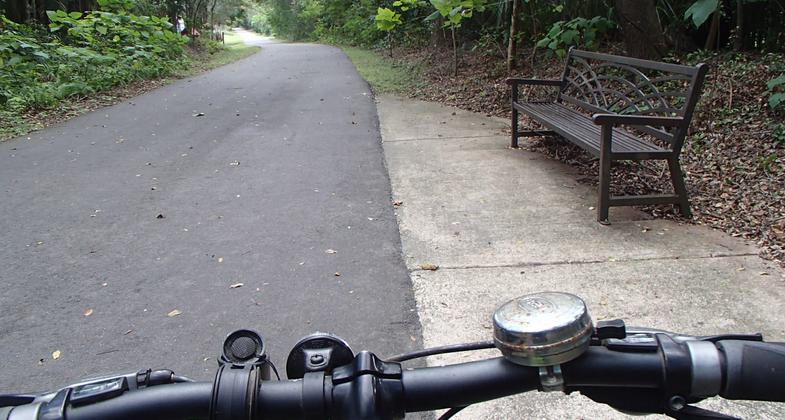
Trail view through the handlebars. Photo by Doug Alderson.

Near the trailhead at the southern terminus. Photo by Jim Walla.

Near the trailhead at the southern terminus. Photo by Jim Walla.

Bike rack along trail. Photo by Doug Alderson.

Trail murals. Photo by Doug Alderson.

Mural along trail. Photo by Doug Alderson.

Seminole Wekiva Trail Tunnel. Photo by Doug Alderson.
Location: The Seminole Wekiva Trail begins at the San Sebastian Trailhead in Altamonte Springs and continues approximately 14 miles, ending at the Wekiva River.
- States: Florida
- Counties: Seminole
- Cities/Townships: Altamonte Springs, Longwood, Lake Mary, Sanford
The diverse Seminole Wekiva Trail begins at the San Sebastian Trailhead in Altamonte Springs and continues 14 miles ending at the Wekiva River. It was built over the former Orange Belt Railway, at one time the longest railroad in the country. From Altamonte Springs the trail begins across a pleasant wooden bridge at the San Sebastian Prado trailhead. The first 7 miles traverse quiet residential neighborhoods and lush woods. Draped with Spanish moss, the tree canopy provides welcome shade.
Two miles in you'll reach the ball fields and open park space of the Seminole County Softball Complex. Stop by for a variety of recreational activities at multiple park facilities or for lunch or coffee before entering the new tunnel crossing State Road 434. Continue through Jones Trailhead, beautifully canopied neighborhood areas, pastures, and open space before visiting Heathrow for dining or shopping. Continue through Heathrow's high-tech corridor to the colonial Town Plaza for entertainment, dining, and nightlife! Just past Mile Marker 9, a spur trail on the right leads east to a pedestrian bridge over I-4 before joining the Cross-Seminole Trail.
The final 4 miles of the Seminole-Wekiva mirror the peaceful wooded areas that began the trail. At the trail's end, the Markham Road trailhead offers ample parking and restroom facilities.
Accessibility Information
No text provided.
Allowed Uses:
Bicycling Dogs, on leash Hiking/WalkingOther Activities
- Heritage and history
- Wildlife viewing / observation
Public Contact
Lori HartsockSeminole County Greenways and Natural Lands
3485 N. County Road 426
Geneva, FL 32732
[email protected] • 407-349-0959
Contact the trail manager for current maps and visiting details.
More Details
- Elevation (low): --
- Elevation (high): --
- Elevation (cumulative): --
- Part of a Trail System? No
- Surface (primary): Paved
- Surfaces (additional): Paved
- Tread Width (average): 127"
- Tread Width (minimum): 127
- Running length (minimum): --
- Tread Grade (average, percent): --
- Tread Grade (maximum):
- Running length (maximum): --
- Cross-slope (average, percent): 0
- Cross-slope (maximum): --
- Running length (maximum): --
- Certified as an NRT
May 29, 2012

