Settles Bridge Park Trails
check with the trail manager for updated details before visiting.
Settles Bridge Park Trails
City, Town, or County
Backcountry Trail
- Length
4.5 miles
- Elevation Gain
--
- Route Type
out & back
- Length
4.5 miles - Elevation Gain
-- - Route Type
out & back
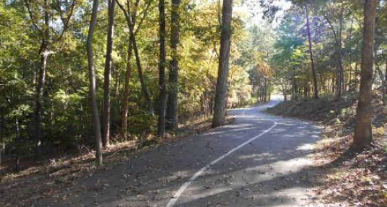
Settles Bridge offers a multi-use trail system that includes 4.5 miles of trails inside a 268-acre park. 1.6 miles of paved trails and 2.9 miles of natural surface trails are heavily wooded and offer a variety of wildlife and fitness opportunities. Conveniently located adjacent to the Chattahoochee River and a local elementary school, Settles Bridge Park trails allow for environmental studies, fitness activities, and a nature experience for the suburban family, and visitors as well.


Settles Bridge Park. Photo by Photographer's Full Name (if d.

Photo by David Firestine.

Photo by David Firestine.

Paved Trail

Natural Surface Trail

Settles Bridge Entrance
Location: Settles Bridge Park, 380 Johnson Road, Suwanee, GA 30024, Gwinnett County Georgia
- States: Georgia
- Counties: Gwinnett
- Cities/Townships: Suwanee
Competed in 2009, this 268-acre park features something for the entire family from 5 miles of trails, an off-leash dog park, a 10,000-foot skate park, a playground, a pavilion, and outdoor basketball courts this park has it all. Funding for Settles Bridge Park was made possible through the 2005 Special Purpose Local Option Sales Tax (SPLOST) and totaled $3.6 million in construction costs. Settles Bridge Park is situated on the upper banks of the Chattahoochee River in the Upper Piedmont of Georgia. The site has a history of farming practices and is now primarily a successional forest with concentrations of pine stands. Mature specimen trees and a greater diversity of native understory shrub layers and ground cover occur in stream corridor ravines that were spared from clearing during the agricultural occupation. Identified categories of vegetation include oak-hickory forest, pine forest, bluff slope ravine forest, bottomland/floodplain forest, successional forest, erosion gully, and invasive exotics. The entire Settles Bridge Park Site is within the Upper Chattahoochee River Watershed. Nearly all storm water drains into the Chattahoochee through a well-defined series of unnamed tributaries and intermittent swales. Some swales remain dry except during rain events while others have some water in them at all times.
Settles Bridge Park offers both multi-use paved trails and natural surface nature trails. The asphalt-paved, twelve-foot wide multi-use trail is accessible from the parking area. Several loops circulate around the amenity areas and into a portion of the woodland. These trails are concentrated near the main areas of park development and do not extend beyond the southern half of the 268-acre park parcel. Trails are routed to deliberately pick up locations on the park property that exhibit cultural resource features. These elements are maintained and highlighted with interpretive signage to educate visitors about the region's unique heritage. The nature trails offer a natural surface walking path network for pedestrian use throughout the park and offer access to the trails leading to the Chattahoochee River that are maintained by the National Park Service. There are two types of unpaved trails: eight-foot wide (mostly existing routes that follow former road beds); and six-foot wide natural surface footpaths that connect into the more remote areas of the parkland. Footbridges are part of the trail system where needed to traverse swales and tributary streams.
Settles Bridge Park is a gateway to the Chattahoochee River, offering opportunities for recreation and fitness to local residents. Suwanee has been recognized by Money Magazine as one of the country's best small communities in which to live and by Kiplinger.com as one of the best communities in which to raise children. Having this park and trail system available in a fast-growing community will offer opportunities to lower nature deficit for generations to come.
Accessibility Information
No text provided.
Allowed Uses:
Bicycling Dogs, on leashOther Activities
- Wildlife viewing / observation
Public Contact
Glenn BoormanGwinnett County Parks and Recreation
Lawrenceville, GA 30046
[email protected] • (770) 822-8873
Contact the trail manager for current maps and visiting details.
More Details
- Elevation (low): 930
- Elevation (high): 1080
- Elevation (cumulative): --
- Part of a Trail System? No
- National Designations: NA
- State Designations: NA
- Surface (primary): Paved
- Surfaces (additional): Soil, Wood chips/mulch
- Tread Width (average): 127"
- Tread Width (minimum): 72
- Running length (minimum): --
- Tread Grade (average, percent): 4
- Tread Grade (maximum): 8
- Running length (maximum): --
- Cross-slope (average, percent): 2
- Cross-slope (maximum): --
- Running length (maximum): --
- Certified as an NRT
Jun 2, 2014

