Shingobee NRT
This information is a public record of the 1982 NRT application and may be out of date if it has not been updated by a trail manager --
check with the trail manager for updated details before visiting.
check with the trail manager for updated details before visiting.
Shingobee NRT
USDA Forest Service
Backcountry Trail
- Length
6 miles
- Elevation Gain
--
- Route Type
out & back
- Length
6 miles - Elevation Gain
-- - Route Type
out & back
The area offers six miles of trails in the heart of Minnesota's north woods.

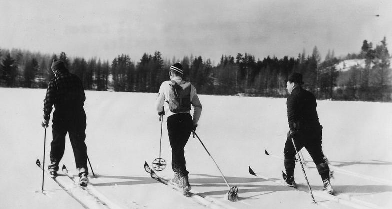
Vintage 1940 ski party crossing a small frozen lake on one of the ski trails at Shingobee Winter Playground. Photo by Dept of Agriculture/wiki.
Location: Chippewa National Forest; Walker Ranger District
- States: Minnesota
- Counties: Cass
The Shingobee Recreation Area provides a variety of summer and winter activities. The area offers six miles of trails in the heart of Minnesota's north woods. Sections of the trail may be wet in the spring. the ski trails are intermediate to advanced in difficulty and are groomed and track-set each winter. Visitors are encouraged to use caution when sledding and skiing in the winter due to steep slopes and changing environmental conditions. Campers will need to bring in water and pack out all garbage.
Accessibility Information
No text provided.
Allowed Uses:
Dogs, on leash Hiking/Walking Snow, cross-country skiingOther Activities
- Camping
- Snow, snow play general
Public Contact
Loree AlbrightChippewa National Forest
201 Minnesota Ave. East
Walker, MN 56484
[email protected] • (218) 547-1044
www.fs.fed.us/r9/chippewa
Contact the trail manager for current maps and visiting details.
More Details
- Elevation (low): 1302
- Elevation (high): 1350
- Elevation (cumulative): --
- Part of a Trail System? No
- Surface (primary): Grass or Vegetation
- Surfaces (additional): Grass or Vegetation
- Tread Width (average): 48"
- Tread Width (minimum): --
- Running length (minimum): --
- Tread Grade (average, percent): 3
- Tread Grade (maximum): 6
- Running length (maximum): --
- Cross-slope (average, percent): --
- Cross-slope (maximum): --
- Running length (maximum): --
- Certified as an NRT
Mar 28, 1982

