Sisson-Callahan
check with the trail manager for updated details before visiting.
Sisson-Callahan
USDA Forest Service
Backcountry Trail
- Length
9 miles
- Elevation Gain
--
- Route Type
out & back
- Length
9 miles - Elevation Gain
-- - Route Type
out & back
This nine-mile trail winds through some of the most spectacular mountain scenery in Northern California, climbing from the canyon of the North Fork of the Sacramento River up into the mountains of the Trinity Divide near Mt. Eddy.

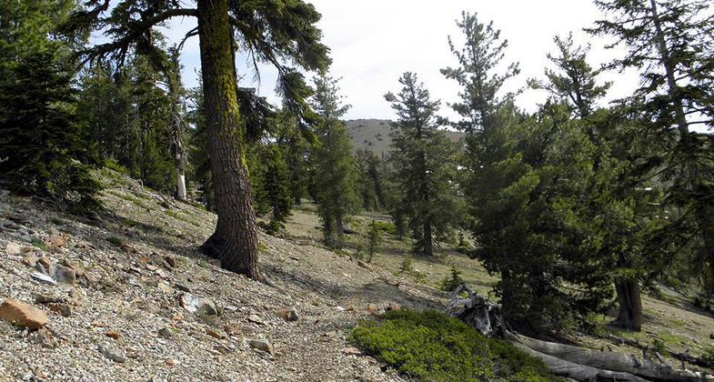
Sisson Callahan trail. Photo by Steve Lewis.

Sisson Callahan Trail to Mt. Eddy. Photo by Steve Lewis.

Brown bear showing up for a photo shoot!. Photo by Steve Lewis.
Location: In Shasta-Trinity National Forest, W of I-5, connects to Pacific Crest NST.
- States: California
- Counties: Siskiyou
This nine-mile trail winds through some of the most spectacular mountain scenery in Northern California, climbing from the canyon of the North Fork of the Sacramento River up into the mountains of the Trinity Divide near Mt. Eddy.
The Trinity Divide encompasses the high mountains beginning with China Peak in the north all the way to Shasta Bally in the south and generally divides the Valley of the Trinity River in the west from the Sacramento River Canyon in the east. It is an area of rugged peaks, emerald-green meadows, rushing streams, and gorgeous alpine lakes. The Sisson-Callahan National Recreation Trail visits the heart of this country. The entire length of the trail is visited with stunning views of Mt. Shasta, Mt. Eddy, Castle Crags, and the Trinity Alps.
The trail crosses Deadfall Summit above Deadfall Lakes at the 8,020-foot elevation. Spring hikers will likely find snow at the summit well into early summer and yet be able to enjoy the heady fragrance of azaleas in bloom down along the North Fork of the Sacramento River. From Deadfall Summit it is an easy walk to the top of Mt. Eddy for an awe-inspiring view of the surrounding country.
An amazing variety of conifer species occur throughout the area, and wildflowers carpet the meadows and hillsides. Water is plentiful and campsites are found at frequent intervals along the trail. Fishing is popular along the North Fork of the Sacramento River, which the trail follows closely, and at Deadfall Lakes near the western end of the trail.
Accessibility Information
No text provided.
Allowed Uses:
Hiking/WalkingOther Activities
- Camping
- Fishing
Public Contact
Jerry HarmonShasta -Trinity National Forest
Shasta Zone Engineering
Mt. Shasta, CA 96067
(530) 926-9627
Contact the trail manager for current maps and visiting details.
More Details
- Elevation (low): --
- Elevation (high): --
- Elevation (cumulative): --
- Part of a Trail System? No
- Surface (primary): --
- Surfaces (additional): --
- Tread Width (average): 18"
- Tread Width (minimum): --
- Running length (minimum): --
- Tread Grade (average, percent): --
- Tread Grade (maximum):
- Running length (maximum): --
- Cross-slope (average, percent): --
- Cross-slope (maximum): --
- Running length (maximum): --
- Certified as an NRT
Dec 12, 1979

