Snoqualmie Valley Trail
check with the trail manager for updated details before visiting.
Snoqualmie Valley Trail
City, Town, or County
Backcountry Trail
Frontcountry Trail
Rail Trail
- Length
31 miles
- Elevation Gain
--
- Route Type
out & back
(1 review)
- Length
31 miles - Elevation Gain
-- - Route Type
out & back
The Snoqualmie Valley Trail occupies the historic path of a spur line of the Chicago, Milwaukee, St. Paul, and Pacific Railroad. The trail is King County's longest and perhaps most majestic trail, paralleling the Snoqualmie River for more than 31 miles from Duvall to Rattlesnake Lake just outside of North Bend. The trail connects multiple rural communities, providing a safe gravel path for bicycling, walking, and horseback riding.
Location: The Snoqualmie Valley Trail starts at Rattlesnake Lake outside of North Bend and ends at McCormick Park in Duvall.
- States: Washington
- Counties: King
- Cities/Townships: Duvall, Carnation, Fall City, Snoqualmie, North Bend
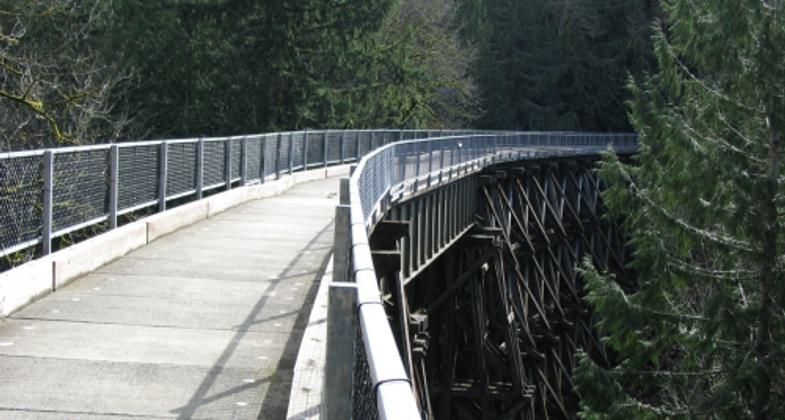
The Snoqualmie Valley Trail is King County's longest and perhaps most majestic trail. Paralleling the Snoqualmie River for more than 31 miles from Duvall to Rattlesnake Lake just outside North Bend, the Snoqualmie Valley Trail connects communities and provides ever-changing views, access to natural areas along the riverbank, historic rail trestles, and many opportunities to observe wildlife and enjoy the beauty of the Snoqualmie Valley.
The Snoqualmie Valley Trail occupies the historic path of a spur line of the Chicago, Milwaukee, St. Paul & Pacific Railroad. The Milwaukee Road, as it was known, shaped the history of the region by serving as an artery of commerce and communication between the Eastern states and the previously isolated Pacific Northwest. The Milwaukee Road completed a transcontinental railroad over Snoqualmie Pass in 1909, connecting Puget Sound with the rest of the country.
The railroad industry served as the foundation for quickening the settlement of the region. Rail towns sprang up along the main lines, and spurs off the main line paved the way for timber mill towns that brought immigrant workers who bolstered the population, and whose descendants still live here today. Communities prized their railway depots as the town center for news, mail, and business. When the railroad was built into the Snoqualmie Valley, the town of Duvall picked up and moved to accommodate the optimal route of the tracks. Today the railway, converted to the Snoqualmie Valley Trail in the 1980s, continues to connect communities.
The Snoqualmie Valley Trail starts at Rattlesnake Lake outside of North Bend and ends at McCormick Park in Duvall. The trail follows the Snoqualmie River as it winds through forests, historic sites, and farmland. Several historic sites along the trail are recognized for their importance, including the North Bend Ranger Station and Civilian Conservation Corps Camp Waskowitz on the National Register of Historic Places and the North Bend Covered Railroad Bridge on the State Historic Register. Near the trail, visitors can ride a historic train between the communities of Snoqualmie and North Bend, run by the Northwest Railway Museum. Along the way, one can stop at their Railway History Center which includes the expansive Conservation and Restoration Center, where historic railway artifacts are restored by volunteers. The trail crosses Snoqualmie Falls, a Hydroelectric Power Plant Historic District, a Traditional Cultural Property, and the most popular tourist attraction in the Valley.
The Snoqualmie Valley Trail continues to serve as an arterial route, as it did in the railroad days, connecting to a number of other regional trails. Seattle residents can get to the Snoqualmie Valley almost entirely on a separate trail, starting with the former Northern Pacific Railroad route, now the Burke-Gilman Trail, to the Tolt Pipeline Trail, which intersects the Snoqualmie Valley Trail. The Snoqualmie Valley Trail also connects to the Interstate 90 corridor and to Issaquah, Bellevue, and other Eastside cities via the Preston-Snoqualmie Trail. At the trail's southern terminus at Rattlesnake Lake, it joins with the main line of the old Milwaukee Road, now the John Wayne Pioneer Trail in Iron Horse State Park and already a designated National Recreation Trail, which climbs the Cascades to Snoqualmie Pass and descends to Central Washington and beyond.
As a path open for bicycling, walking, and horseback riding, the Snoqualmie Valley Trail provides clear benefits to the health of local residents and visitors. The scenic route encourages visitors to take a healthy, self-powered tour of the valley. For the residents of the communities along the trail, it serves as a conduit to surrounding natural areas. The students of Riverview Learning Center, Tolt Middle School, and the Two Rivers School use trails to get to nearby forests and rivers for field study sessions.
The last train ran through the Cascades on the Milwaukee Road in 1980. Washington State Parks acquired the main line of the Milwaukee Road and King County Parks acquired a spur line that would become the Snoqualmie Valley Trail. In the following decades, King County turned the railroad into a gravel path for hikers, bicyclists, and trail enthusiasts of all ages and abilities. The Snoqualmie Valley Trail is the single longest trail in King County's Regional Trail System, one of the nation's most extensive multi-use, off-road systems with over 175 miles of trail. New spurs and connections to the Snoqualmie Valley Trail are part of a planned network of 300 miles of trails that King County is actively planning and developing.
The Snoqualmie Valley Trail merits the National Recreational Trail designation for its magnificent natural setting, connection to railway heritage in our region, an extension of an existing National Recreational Trail, and its location connecting urban residents to a spectacular rural river valley.
Accessibility Information
No text provided.
Reviews
A gem in the Snoqualmie Valley
Snoqualmie Valley Trail is one of the best things about living in the Snoqualmie valley. The trail is mellow, beautiful and great for a lot of activities from walking to running to biking to horseback riding. It also connects to the massive Iron Horse Trail for those looking for a long cycling adventure.
Allowed Uses:
Bicycling Dogs, on leash Equestrian Hiking/WalkingOther Activities
- Heritage and history
- Wildlife viewing / observation
Public Contact
Monica LeersKing County Parks Division
201 South Jackson Street
Seattle, WA 98104
[email protected] • (206)477-4575
Contact the trail manager for current maps and visiting details.
More Details
- Elevation (low): 40
- Elevation (high): 940
- Elevation (cumulative): --
- Part of a Trail System? No
- Surface (primary): Rock, crushed
- Surfaces (additional): Paved
- Tread Width (average): 10"
- Tread Width (minimum): 10
- Running length (minimum): --
- Tread Grade (average, percent): --
- Tread Grade (maximum): 3
- Running length (maximum): --
- Cross-slope (average, percent): 0
- Cross-slope (maximum): --
- Running length (maximum): --
- Certified as an NRT
Jun 3, 2015


