South Fork of Trinity River NRT
check with the trail manager for updated details before visiting.
South Fork of Trinity River NRT
USDA Forest Service
Backcountry Trail
- Length
8 miles
- Elevation Gain
--
- Route Type
out & back
- Length
8 miles - Elevation Gain
-- - Route Type
out & back
The trail follows the wild and scenic South Fork Trinity River corridor.

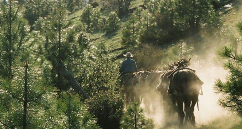
Dusty trail into base camp. photo by Julie Green.

Showing new crew how to use the crosscut saw on a tree across the trail. Photo by Julie Green.

USFS and CCC staff check map for trail clearing. Photo by Julie Green.

Ohlone Riders Unit heading thru burn area. Photo by Julie Green.
Location: On the Shasta-Trinity National Forest, south from Forest Glen on SR 36.
- States: California
- Counties: Trinity
This trail has gentle grades making it very enjoyable for family hiking. In a few locations the trail does cross private property, so please be respectful. The trail follows the wild and scenic South Fork Trinity River corridor.
No motorized vehicles are allowed on any portion of the trail.
A longer hike is available if you want to continue upriver for ten miles to the Double Cabins site at the Wild-Mad Road (FS 29N30). You will encounter spectacular views from bluffs along the river, deep forests of fir, pine, and oak, open meadows, and a scenic river corridor. The South Fork of the Trinity River headwaters begin in the highest portions of the Yolla Bolly-Middle Eel Wilderness and flow northward to the main stem of the Trinity River. It is one of the wildest and most scenic rivers in Northern California.
Current fishing regulations allow for artificial lures only with barbless hooks from November 1 through March 31. All trout and steelhead must be released immediately unless they show a healed adipose fin clip. See current regulations at www.wildlife.ca.gov/Regulations.
Accessibility Information
No text provided.
Allowed Uses:
Equestrian Hiking/WalkingPublic Contact
Sally CousinsUS Forest Service
Trinity River Management Unit
Weaverville, CA 96093
[email protected] • (503) 623-1782
www.fs.usda.gov/stnf
Contact the trail manager for current maps and visiting details.
More Details
- Elevation (low): 2200
- Elevation (high): 2700
- Elevation (cumulative): --
- Part of a Trail System? No
- Surface (primary): Soil
- Surfaces (additional): --
- Tread Width (average): 30"
- Tread Width (minimum): --
- Running length (minimum): --
- Tread Grade (average, percent): 5
- Tread Grade (maximum): 10
- Running length (maximum): --
- Cross-slope (average, percent): --
- Cross-slope (maximum): --
- Running length (maximum): --
- Certified as an NRT
May 5, 1980

