Stowe Recreation Path
check with the trail manager for updated details before visiting.
Stowe Recreation Path
City, Town, or County
- Length
5.3 miles
- Elevation Gain
--
- Route Type
out & back
(1 review)
- Length
5.3 miles - Elevation Gain
-- - Route Type
out & back
Curves back and forth over the Little River among meadows, covered bridges, and with views of Mt. Mansfield.

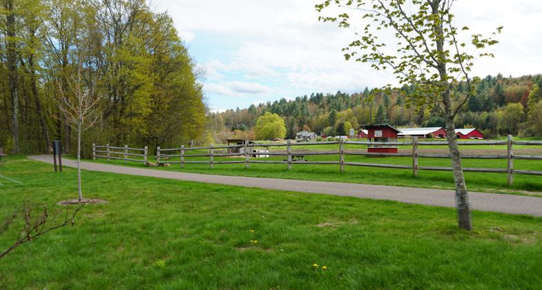
Scenery along the path. Photo by Stowe Area Association.

Fall colors on the Stowe Recreation Path. Photo by Kelli Millick.

Scenery along the Stowe Recreation Path. Photo by Kelli Millick.

Creek along recreation path. Photo by Stowe Area Association.

Field and mountain view. Photo by Stowe Area Association.

Corn maze. Photo by Stowe Area Association.

Bridge on pathway. Photo by Stowe Area Association.

Mountain view on Stowe Recreation Path. Photo by Stowe Area Association.
Location: suburban
- States: Vermont
The Stowe Recreation Path is an internationally recognized greenway stretching from Stowe Village to Top Notch Resort on Mountain Road. Residents and guests alike enjoy the 5.3-mile paved trail as it crisscrosses the West Branch of Little River. Breath-taking mountain views and access to restaurants, lodges, and local businesses make the bike path one of the most popular recreation assets in Stowe.
In 2010, Friends of Rec Path Grooming and several community members presented a proposal to the Select Board asking to have the path groomed during the winter. In 2011, following the efforts of the community, Stowe Town purchased the equipment needed to maintain the path during the cold months and opened it up for all-season use. Now, the path is open to walkers, runners, bikers, snowshoers, cross-country skiers, and rollerbladers. During the winter, GMTA’s free winter shuttle provides transportation along the mountain road if you’re looking for a one-way trip!
In the spring of 2017, Bike maintenance stations at Lintilhac Park and Chase Park were installed. Bike maintenance stations include all the tools necessary to perform basic bike repairs and maintenance, from changing a flat to adjusting brakes and derailleurs. Hanging the bike from the hanger arms allows the pedals and wheels to spin freely while making adjustments.
Accessibility Information
No text provided.
Reviews
Janie Walker
Vermont At Its Finest
June 19th, 2023. Lovely trail going in and out of woods, sometimes with views of nearby Mansfield. There are ten numbered and charming wood-planked bridges to cross, and also shops and ice-cream/food opportunities along the way. I saw people of all ages walking, jogging, roller-blading, and biking. Stowe is pure New England gorgeousness, so I had a lovely time walking this path along the most Vermont-y of Vermont landscapes.
Allowed Uses:
Bicycling Swimming Dogs, on leash Hiking/Walking Snow, cross-country skiingOther Activities
- Camping
- Snow, snow play general
Public Contact
Town of StoweTown Clerks Office
Stowe, VT 5672
(802) 253-7758/
Contact the trail manager for current maps and visiting details.
More Details
- Elevation (low): --
- Elevation (high): --
- Elevation (cumulative): --
- Part of a Trail System? No
- Surface (primary): --
- Surfaces (additional): --
- Tread Width (average): 96"
- Tread Width (minimum): --
- Running length (minimum): --
- Tread Grade (average, percent): --
- Tread Grade (maximum):
- Running length (maximum): --
- Cross-slope (average, percent): --
- Cross-slope (maximum): --
- Running length (maximum): --
- Certified as an NRT
Nov 14, 1990

