Sugar Bottom Mountain Biking Trail System
check with the trail manager for updated details before visiting.
Sugar Bottom Mountain Biking Trail System
U.S. Corps of Engineers
Backcountry Trail
- Length
13 miles
- Elevation Gain
--
- Route Type
Loop
- Length
13 miles - Elevation Gain
-- - Route Type
Loop
Sugar Bottom Mountain Biking Trails are approximately 13 miles of single track, one way trails. There are a variety of trails from easy, to moderate, to difficult.
Location: At Sugar Bottom Day Use Recreation Area, in rural Johnson County, between North Liberty and Solon Iowa.
- States: Iowa
- Counties: Johnson
- Cities/Townships: Penn
Set in rugged terrain surrounding the Coralville Reservoir on the Iowa River, the trail presents design challenges as well as the potential for spectacular trails. The trails are graded similarly to ski trails as easy (green), moderate (blue), and difficult (black). The trail system is arranged as a one-way system of loops. There are 3 easy main loops, with 3 or 4 loops off of each of these which are rated at the higher difficulty levels. The difficult trails enter more rugged terrain and the trails have steeper climbs, descents, and tight turns. The layout of the trail is one of the best anywhere for flow, and the one-way design with complete directional signage enhances safety. The location in east-central Iowa next to the Sugar Bottom campground, Coralville Lake, and near Iowa City and Cedar Rapids make this a great destination for mountain bikers.
History of the Trail System
In the mid to late 1980's there was not a public use area or a road to where the beach and trailhead are now located. Local riders were riding a small system of ad hoc trails. In 1990, a one-mile section of trail was cut in, in the area of the current 101 trail and a race was held.
The USACE agreed to support a mountain bike trail system at Sugar Bottom if an organization was created so there could be a formal interface. ICORR was formed and incorporated in 1991. After ICORR had proven itself with the one-mile initial 101 loop, trail layouts were approved for the south peninsula. By 1994 the total trail length totaled 5 miles. Expansion of the trail system continued in the mid-1990s with mileage reaching 10.
Sugar Bottom is essentially the birthplace of mountain biking in Iowa, inspiring other trails and clubs throughout the state. In 2012, the 20th Sugar Bottom Scramble was held. The Scramble is the longest continuously running mountain bike race in the state.
Design and Evolution
Two features of the Sugar Bottom Recreation Area present design challenges for trails. One is the soil which has very high clay content just below the thin organic layer. This can easily erode once the narrow trail tread becomes compressed and free of vegetation. Trails with the proper slope ratios along and across the trail, and features like grade changes, grade dips, and direction changes are still in good condition after nearly 20 years of use. The sugar bottom trails contain no artificial elements to control erosion other than wood bridges to cross natural drainages.
The other feature of the area is the beautiful Coralville Reservoir. When the lake rises during times of high rainfall, the ravines adjacent to the lake fill with water. Over the past decade, areas of trails that had proven to be problematic with erosion or chronic wet areas were redesigned to newer improved standards. The design improvements added meandering characteristics to the trails gradually increasing the overall distance to 13 miles, solely through rerouting of existing trails.
The smooth interfaces with the loop trails create an extended continuous riding experience. Riding the entire system takes close to 1.5 hours at a moderately high pace which has great potential for fitness development.
Management Direction
In the last decade, the trail design focus has been to reduce the amount of regular maintenance the trails require to correct drainage. Trails not well located or with slope and drainage issues have been systematically redesigned over time to reduce the amount of regular drainage maintenance. All trails on the softer ground need drainage tuning occasionally, but the goal was to have no maintenance required after significant rainfall, with the trails naturally drying out uniformly.
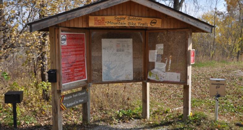
Signage has been improved over the last few years with complete directional signage for the one-way trail system. During high water on the Coralville reservoir, the gravel access road has sections that are inundated. This requires temporary rerouting of some trails to be two-way. A series of signs were developed which have covers that can be quickly opened during high water events to redirect trail usage safely during these times. Previously this had been more difficult requiring the deployment of special signs for this purpose.
The other main regular effort is maintaining an open trail corridor during the growing season. Some new equipment has been acquired to make this a more efficient process as it can be time-consuming.
ICORR conducts two regularly scheduled monthly trail maintenance days which are well advertised through the web, email, and phone hotline. These are supported by volunteers who are users of the trail. Typically around 600 hours are recorded for trail maintenance each year.
The goal is to have a beautiful and challenging trail system suitable for both novices and experts which is both sustainable and relatively easy to maintain.
Accessibility Information
No text provided.
Allowed Uses:
Bicycling Dogs, on leash Hiking/WalkingOther Activities
- Wildlife viewing / observation
Public Contact
Jeffrey PeckU. S. Army Corps of Engineers
2850 Prairie Du Chien Rd NE
Iowa City, IA 52240
[email protected] • (319) 338-3543 ext. 63
Contact the trail manager for current maps and visiting details.
More Details
- Elevation (low): 679
- Elevation (high): 840
- Elevation (cumulative): --
- Part of a Trail System? No
- Surface (primary): Soil
- Surfaces (additional): Grass or Vegetation, Rock, crushed, Soil
- Tread Width (average): 96"
- Tread Width (minimum): 48
- Running length (minimum): --
- Tread Grade (average, percent): 5
- Tread Grade (maximum): 30
- Running length (maximum): --
- Cross-slope (average, percent): 2
- Cross-slope (maximum): --
- Running length (maximum): --
- Certified as an NRT
May 29, 2013