Sun Circle Trail
check with the trail manager for updated details before visiting.
Sun Circle Trail
City, Town, or County
Backcountry Trail
Urban Trail
- Length
120 miles
- Elevation Gain
--
- Route Type
out & back
(1 review)
- Length
120 miles - Elevation Gain
-- - Route Type
out & back
Much of this trail was established in the 1960s and 1970s by some very dedicated citizens in the Phoenix area.
Location: Phoenix Arizona, parallels the Arizona Canal and the Southern and Consolidated Canals.
- States: Arizona
- Counties: Maricopa
The Sun Circle Trail #1 is classified as an existing trail, however, some portions of this 300-mile loop trail that encircles the Valley of the Sun in Phoenix are either incomplete or difficult to find.
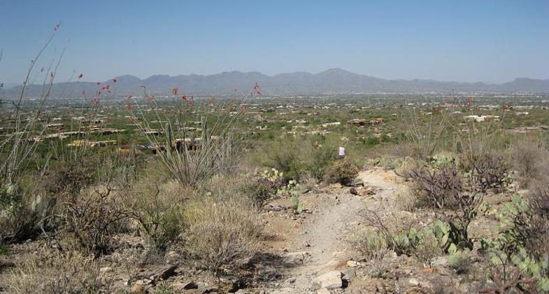
The Sun Circle Trail links many of the communities in the Valley of the Sun, including Glendale, Sunnyslope, Paradise Valley, Scottsdale, Mesa, Gilbert, Chandler, Guadalupe, Laveen, Avondale, and Phoenix. It is an urban area trail in some locations, and in others, it passes through parks and preserved open space within the boundaries of several municipal jurisdictions. It parallels the Arizona Canal and the Southern and Consolidated Canals through many communities and eventually passes through the Salt River Pima Indian Reservation to reach the eastern point at Granite Reef Dam. Then it follows the Western Canal and enters South Mountain Park, where it follows the natural summit line of South Mountain for more than 15 miles, which is named the Summit Trail #162.
Summit Trail #162 is frequently referred to as the National Trail and is a part of the Sun Circle National Recreational Trail. It extends from the east to west extremities of South Mountain Park, which is the largest municipal park in America. The east section of this 15.25-mile trail is reached at the end of Guadalupe Road at 48th Street at the Pima Canyon Trailhead. The west trailhead located at the end of San Juan Road is reached through the main entrance to South Mountain Park at the end of Central Avenue. Both trailheads are located within the City of Phoenix.
Points of interest along the trail include its ridgeline views as it traverses the crest of South Mountain, a prominent and large landmark in the Valley of the Sun, as well as unusual geologic formations such as window rock, a natural bridge, a natural tunnel, a natural dike known as 'The Chinese Wall,' and Hidden Valley where you try to crawl through Fat Mans Pass.
Historic sites include Marcos de Niza rock where Coronado is believed by some to have passed on his search for the Seven Cities of Cibola. There are numerous well-preserved ancient petroglyphs on the canyon walls and special landmark rock carvings that align perfectly with the shadows created on the Equinox and Solstice, much as those found in Machu Pichu.
The Sun Circle Trail is also highlighted in the book Day Hikes and Trail Rides In and Around Phoenix, by authors Roger and Ethel Freeman, 1991, Gem Guides Book Co., 315 Cloverleaf Drive, Suite F, Baldwin Park, CA 91706. This publication has the following information: One of the most popular segments of the Sun Circle Trail is the National Trail which leads from Pima Canyon at the east end and ends at San Juan Point. The National Trail and South Mountain Park area is alleged to have been claimed for Spain by Father Marcos de Niza, traveling through the area in 1539. His alleged inscription is to be seen on the short trail section south of the ramadas off Pima Canyon Road at the east end of South Mountain Park.
The area to the east of the Park was the Yaqui Indian village of Guadalupe. Ancestral petroglyphs found on numerous rock surfaces along the National Recreation Trail are between 500-1500 years old.
In 1694 Father Kino passed through this same area, but the first Americans did not arrive until approximately 1838. Charles Holbert became the first custodian of the new park in 1929 and helped develop the trail along the summit with the assistance of the Civilian Conservation Corps.
Today the National Trail is used extensively by hikers, mountain bikers, and equestrians. It is one of the most popular National Scenic Trails in the state of Arizona. Maricopa County is the official map keeper for this trail, and the best person to contact would be Bill Scalzo, who is head of the Maricopa County Parks & Recreation Dept. Maricopa County is the Board of Supervisors designated map provider for this trail and the person to contact is Dawna Taylor, Public Information Officer, Maricopa County Parks and Recreation Department.
Accessibility Information
No text provided.
Reviews
Ann Connolly
Sun Circle Trail
I have walked about 100 miles of this 120 mile loop trail. Much of it is urban and along canals. I am walking it in segments. I only had trouble finding my way in a couple of places. The part I have not walked is not developed yet. The route gave me a different perspective of this Phoenix metro area I have lived in most of my life.
Allowed Uses:
Bicycling Equestrian Hiking/WalkingPublic Contact
Maricopa County Parks41835 N. Castle Hot Springs Road
Morristown, AZ 85342
[email protected] • (602) 506-9500
www.maricopa.gov/park
Contact the trail manager for current maps and visiting details.
More Details
- Elevation (low): --
- Elevation (high): --
- Elevation (cumulative): --
- Part of a Trail System? No
- Surface (primary): Rock, crushed
- Surfaces (additional): Soil
- Tread Width (average): 48"
- Tread Width (minimum): --
- Running length (minimum): --
- Tread Grade (average, percent): 1
- Tread Grade (maximum): 10
- Running length (maximum): --
- Cross-slope (average, percent): --
- Cross-slope (maximum): --
- Running length (maximum): --
- Certified as an NRT
Mar 24, 1977


