Swan Creek Greenway Trail
check with the trail manager for updated details before visiting.
Swan Creek Greenway Trail
City, Town, or County
Backcountry Trail
Frontcountry Trail
- Length
2.31 miles
- Elevation Gain
--
- Route Type
out & back
(1 review)
- Length
2.31 miles - Elevation Gain
-- - Route Type
out & back
The Swan Creek Greenway Trail is a 2.3-mile-long shaded trail that parallels Swan Creek, offering pedestrians views of gentle rapids, ample wildlife and lush timberlands. The trail also connects many recreational facilities open to the public.


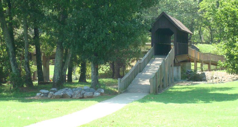
Trail crossing over Big Spring. Photo by Donna Kridelbaugh.

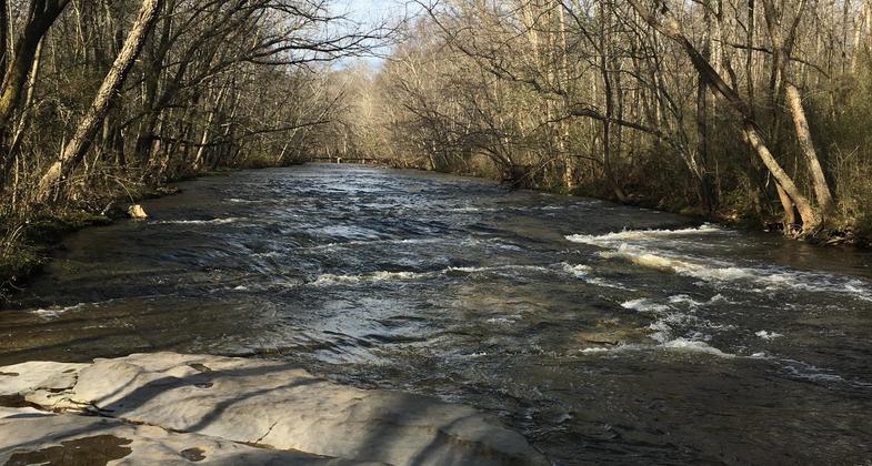
View of Swan Creek with its limestone bed. Photo by Donna Kridelbaugh.

Trail entrance at Athens Sportsplex. Photo by Donna Kridelbaugh.

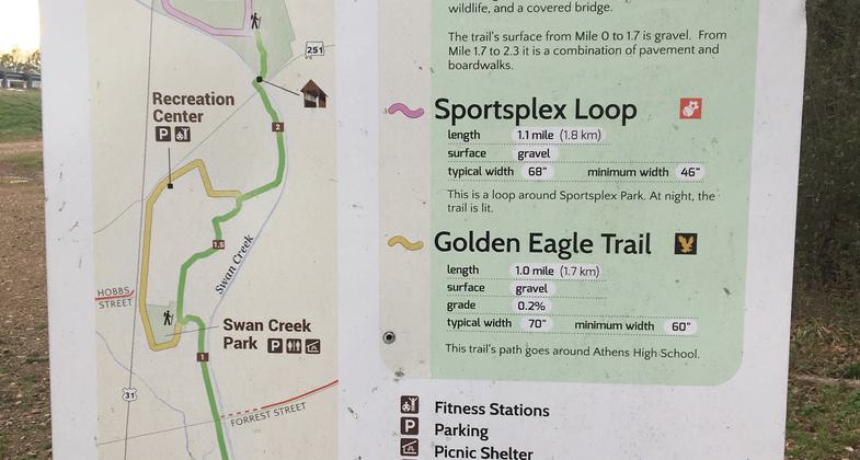
Trail system map. Photo by Donna Kridelbaugh.

Archery range.

Entering the Swan Creek Greenway Trail.
Location: Adjacent to Swan Creek east of US 31 from the Athens Sportsplex to US 72.
- States: Alabama
- Counties: Limestone
- Cities/Townships: Athens
The Swan Creek Greenway Trail is owned and maintained by the City of Athens as an outdoor park and trail. The wooded trail parallels Swan Creek for approximately 2.3 miles, offering scenic views of small rapids and numerous pools along the tributary. The greenway either runs through lands owned by the City or in easements purchased by the City. A swath of mixed timberland is preserved along the creek and the trail. Many species of wildlife indigenous to northern Alabama, including deer, squirrel, chipmunk, and foxes, along with numerous types of fowl and fish, can be viewed and enjoyed by nature enthusiasts and casual pedestrians alike. Among the various types of fish in Swan Creek are the slack water darter, a listed endangered species.
The trail connects with numerous recreational facilities at the City's Sportsplex and Swan Creek Park. The Sportplex is a complex of facilities including baseball fields, soccer fields, a Frisbee golf course, a swimming pool, and a playground. Swan Creek Park, located adjacent to the high school, offers a playground, tennis courts, and a pavilion with picnic tables, grills, and public restrooms. An archery practice range is located in the vicinity of the pavilion. The trail also connects with a loop trail that circles the high school and its athletic complex. With all of these recreational facilities, the Swan Creek Greenway Trail offers the public numerous opportunities to enjoy health benefits and family fun.
The trail has two trailheads: one on US 72 to the south and one at the City's Sportsplex to the north. Beginning at the northern trailhead, the trail meanders through an open greenspace that makes up a portion of the Frisbee golf course. The trail then crosses Swan Creek on a restored covered bridge. After paralleling Swan Creek for approximately 1/3 of a mile, the trail turns west toward the high school, where it crosses a large wetland area on an elevated boardwalk for a full 1/10 of a mile.
After passing the high school, athletic facilities, and Swan Creek Park, the trail re-enters the timberland area along Swan Creek and parallels the tributary to the south trailhead. It is along this 1.2-mile stretch that one experiences the soothing sound and beautiful sight of numerous rapids as the creek cuts its way through its limestone bed. The trail crosses under the Forrest Street bridge over Swan Creek, where it will soon connect with a pedestrian and bicycle path being developed to serve neighborhoods to the east along Forrest Street and Lindsay Lane. About 1/4 of a mile to the south of Forrest Street, the trail crosses Big Spring, the headwaters of which mark where the City of Athens was founded and served as its water supply for many years.
General maintenance is handled by the Parks and Recreation Department, while larger maintenance issues are occasionally dealt with by the Public Works Department. The greenway trail is open to the public 24 hours a day for the entire year. The portion of the greenway trail adjacent to the high school campus and athletic complex, as well as the loop trail around the high school, are illuminated at night. The entire trail was designed in accordance with the standards put forth in the Americans with Disabilities Act. The majority of the trail is dense grade crushed rock, with some segments consisting of concrete, asphalt, and elevated boardwalk.
Accessibility Information
No text provided.
Reviews
Donna Kridelbaugh
NRT Ambassador Review
Swan Creek Greenway Trail is a 2.3-mile, linear trail (4.6 miles roundtrip) located in the heart of Athens, AL. It connects multiple city recreational facilities and the high school and is flanked by two trailheads at either end. The trail features a paved or gravel surface for its entire length and is wide enough for pedestrians and bikers to comfortably share the path. The namesake of the trail is Swan Creek that parallels most of its length. With its clear, rushing waters and pitted limestone bed, the creek provides a seclusive retreat for visitors. To note, there may be some wet spots on the trail near the confluence of Big Spring and Swan Creek. The northern trail entrance is located at the Athens Sportsplex with ample parking spaces. The southern trail entrance is located right off Highway 72 and parking here is not ideal, although the city has plans to develop this trailhead in the future. It also is easy access to the trail from I-65 for any travelers passing through the area. Please remember to Leave No Trace while out on the trail and carry out all your trash.
Allowed Uses:
Bicycling Dogs, on leash Hiking/WalkingPublic Contact
Mac Martin1600 Elm St. W
Athens, AL 35611
[email protected] • (256) 233-2224
www.athensal.u
Contact the trail manager for current maps and visiting details.
More Details
- Elevation (low): 650
- Elevation (high): 680
- Elevation (cumulative): --
- Part of a Trail System? No
- Surface (primary): Rock, crushed
- Surfaces (additional): Paved, Boardwalk
- Tread Width (average): 90"
- Tread Width (minimum): --
- Running length (minimum): --
- Tread Grade (average, percent): --
- Tread Grade (maximum):
- Running length (maximum): --
- Cross-slope (average, percent): --
- Cross-slope (maximum): --
- Running length (maximum): --
- Certified as an NRT
May 19, 2011


