Sweet Springs Turnpike Trail
check with the trail manager for updated details before visiting.
Sweet Springs Turnpike Trail
Private
Backcountry Trail
- Length
1.3 miles
- Elevation Gain
412
- Route Type
Loop
- Length
1.3 miles - Elevation Gain
412 - Route Type
Loop
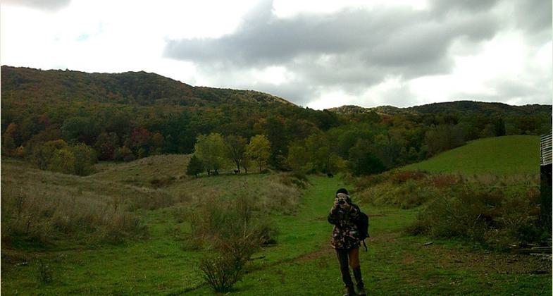
Sweet Springs Turnpike Trail is a user-friendly, multipurpose, progressive and scenic nature trail. From open pastures to dense forest, it is mostly double track with a couple of single-track portions. It’s just over a mile long one way, boasting magnificent views of Sweet Springs Valley and the Andrew S. Rowan Memorial Farm, and beautiful seasonal foliage with a wide variety of tree species, raptors and wildlife. It is a beginner grade hiking and biking trail and is also open to electric mountain bikes and adaptive mountain bikes.


Location: Sweet Springs Turnpike Trail starts behind the office of the Sweet Springs Resort Park at the Park Trailhead (37.62754, - 80.24037) and currently ends with intersection on county route 311 (81/1{32.62013, - 08.23306}) which is the upper portion of the WV side of the original Price's Mountain - Sweet Springs Turnpike.
- States: West Virginia
- Counties: Monroe
- Cities/Townships: Sweet Springs
The Sweet Springs Turnpike Trail runs along a remarkably intact section of the historic 19th century stage road known as The Price's Mountain-Sweet Springs Turnpike (aka The Fincastle-Sweet Springs Turnpike) and is associated with The Historic National Landmark - Sweet Springs Resort Park formally "Old Sweet". Note: Recorded in Deed book 28 page 378 - Botetourt County Circuit Court - sent to Sweet Springs Park by L. Caldwell, Genealogy Researcher of Botetourt County Circuit Court....... " Whereas the General Assembly of VA, did in the month of Feb 1830 (possibly 1836 - hard to tell with handwriting of the day) pass a law authorizing the construction of a Road to be called THE PRICE MOUNTAIN AND SWEET SPRINGS TURNPIKE ...." Many famous people visited the Sweet Springs Park including: 8 of the first 10 Presidents; James & Dolly Madison; Millard Fillmore; Martin Van Buren; Franklin Pierce; Patrick Henry; Robert E. Lee; The Marquis de Lafayette; Jerome Bonaparte (Napoleon’s Brother); and more, some of which traveled here via the Sweet Springs Turnpike. The section of the Turnpike to be designated as the SSTT starts at the Sweet Springs Resort Park on the former Andrew S. Rowan Memorial Farm and ends on top of the western slope of Peters Mountain. It has been cleared and groomed for use as a free public hiking trail and was officially opened on October 15, 2023. It has a number of spectacular views to the southwest and northwest. Doug Woods of the WV Scenic Trails Association walked the trail with us and noted that its location has the potential to link it into and expand the existing Allegheny and Appalachian Trail system. Down the line, we also envision continuing the trail on the eastern side of Peters Mountain and on to Potts Mtn, etc., following the historic Turnpike Road in Virginia. A UNIQUE and one-of-a-kind feature The Sweet Springs Turnpike Trail will offer will be a specialized ADA Trailhead Recreational area. This will be developed to allow those who can't hike the opportunity to enjoy recreational fun as well.
Accessibility Information
Bicycling, Hiking/Walking, E-Biking, Adaptive Mountain Biking, Dogs on Leash, Trail Running, Cross Country SkiingThere will also be a special ADA recreational area at the Trailhead of the trail.
Allowed Uses:
Bicycling Bicycling, hand powered, recumbents, tricycles Dogs, on leash Electric micro-mobility devices Hiking/Walking Snow, cross-country skiing Trail running OtherOther Activities
- Camping
- Heritage and history
- Snow, snow play general
- Wildlife viewing / observation
- Other
Public Contact
Arietta A DuPreSweet Springs Resort Park Foundation Inc.
19540 Sweet Springs Valley Road
Gap Mills, WV 24941, WV 24941
[email protected] • 13045364743
More Details
- Elevation (low): 2063
- Elevation (high): 2475
- Elevation (cumulative): 412
- Part of a Trail System? Yes
- System Name: Sweet Trails System
- System Length: 3.5 miles
- National Designations: NA
- State Designations: NA
- Surface (primary): Grass or Vegetation
- Surfaces (additional): Rock, smooth, Snow or ice, Soil
- Tread Width (average): 48"
- Tread Width (minimum): 36
- Running length (minimum): 2640
- Tread Grade (average, percent): 5
- Tread Grade (maximum): 6
- Running length (maximum): 100
- Cross-slope (average, percent): 3
- Cross-slope (maximum): 5
- Running length (maximum): 100
- Certified as an NRT
May 31, 2024