Tallahassee-St. Marks Historic Railroad State Trail
check with the trail manager for updated details before visiting.
Tallahassee-St. Marks Historic Railroad State Trail
State
Rail Trail
- Length
16 miles
- Elevation Gain
--
- Route Type
out & back
- Length
16 miles - Elevation Gain
-- - Route Type
out & back
The trail runs 16 miles from Florida's capital city to the coastal town of St. Marks. An additional 4.5 miles of trail north of Capital Circle is maintained by the City of Tallahassee. The paved trail provides an excellent workout for bicyclists, walkers, and skaters and features a Boundless Playground. The trail also offers opportunities for horseback riding on the adjacent unpaved trail and access to the Munson Hills Off-Road Trail in the Apalachicola National Forest.

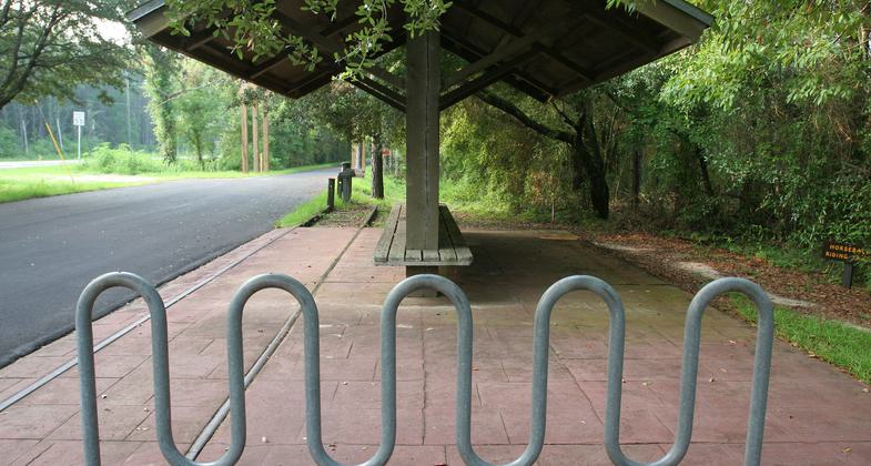
Bike rack and rail section. Photo by Doug Alderson.


Wakulla Station. Photo by Doug Alderson.

Wagon Ride! Photo by Doug Alderson.
Location: Between Tallahassee and St. Marks along SR 363
- States: Florida
- Counties: Leon, Wakulla
- Cities/Townships: Wakulla Station, St. Marks
Managed by the Florida Park Service, the Tallahassee-St. Marks Historic Railroad State Trail is officially designated as part of Florida's Statewide System of Greenways and Trails. The trail follows the abandoned rail bed of the historic Tallahassee-St. Marks Railroad. The state-managed section of the trail runs 16 miles due south from the main trailhead, which is just south of Capital Circle (US 319) southeast, to the coastal Town of St. Marks.
The Florida Board of Trustees of the Internal Improvement Trust Fund (Trustees) holds fee simple title to the property. The property is leased to the park service through December 15, 2043. Development for the paving of the trail was funded by the Florida Department of Transportation.
The trail is a completed section of the developing 120-mile Capital City to the Sea Loop corridor and is a destination along the Big Bend Scenic Byway. The trail provides a scenic experience for over 220,000 annual visitors. Equestrian riders can enjoy the adjacent unpaved trail. An additional 4.5 miles of trail north of the Capital Circle (US 319) trailhead is maintained by the City of Tallahassee. Approximately 1.25 miles south of the main trailhead, outdoor enthusiasts can bike or hike the Munson Hills Trail in the Apalachicola National Forest. The barrier-free Felburn Foundation Boundless Playground® at the Wakulla Station Trailhead is designed to give children of all abilities the opportunity to learn and play freely together. At the southern end of the trail, visitors can enjoy seafood dining and entertainment in the coastal community of St. Marks and learn about the history of the area at San Marcos de Apalachee Historical State Park.
Accessibility Information
No text provided.
Allowed Uses:
Bicycling Dogs, on leash Equestrian Hiking/WalkingOther Activities
- Wildlife viewing / observation
Public Contact
Rob LacyFL Park Service
1358 Old Woodville Highway
Crawfordville, FL 32327
[email protected] • (850) 519-6594
Contact the trail manager for current maps and visiting details.
More Details
- Elevation (low): 4
- Elevation (high): 20
- Elevation (cumulative): --
- Part of a Trail System? No
- Surface (primary): Paved
- Surfaces (additional): --
- Tread Width (average): 96"
- Tread Width (minimum): --
- Running length (minimum): --
- Tread Grade (average, percent): --
- Tread Grade (maximum):
- Running length (maximum): --
- Cross-slope (average, percent): --
- Cross-slope (maximum): --
- Running length (maximum): --
- Certified as an NRT
May 2, 2010


