The Forever Wild Coon Creek Trail System
check with the trail manager for updated details before visiting.
The Forever Wild Coon Creek Trail System
State
Backcountry Trail
Urban Trail
- Length
5 miles
- Elevation Gain
--
- Route Type
Loop
(2 reviews)
- Length
5 miles - Elevation Gain
-- - Route Type
Loop
The 320-acre Forever Wild Coon Creek Tract is located on the banks of Yates Reservoir on the Tallapoosa River.

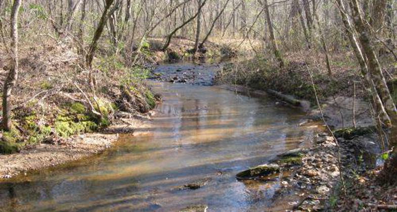
Flowing Coon Creek. Photo by Wayne Barger

Feeder creek flowing into Coon Creek slough. Photo by Ben Coon.

Sunrise at the Boat Ramp
Location: Located within the Forever Wild Coon Creek Tract
- States: Alabama
- Counties: Tallapoosa
- Cities/Townships: Tallassee
The 320-acre Forever Wild Coon Creek Tract was purchased to provide outdoor recreational opportunities. This tract located on the banks of Yates Reservoir on the Tallapoosa River will provide recreational opportunities in the form of hunting, fishing, hiking, and ecological education.
The Forever Wild Coon Creek Tract is home to the Forever Wild Coon Creek Trail System. The trail system consists of two trails; the Wood Duck Trail and the Overlook Loop. The trails are near Yates Reservoir in Tallapoosa County.
The Wood Duck Trail is an easy 4-mile round-trip that begins near the Coon Creek Forever Tract parking lot. The trail heads east hugging the slough of Coon Creek to a picnic area and loops back to the parking lot.
The Overlook Loop also begins near the parking lot and heads west creating a 1-mile loop along the slough to the highest point on the property and back to the trailhead. Overlook Loop is relatively steep in one area, but its short length makes it an easy trek.
Both trails are free to use by the public and provide ample opportunity to observe wildlife including white-tailed deer, wild turkey, wood ducks, and several other bird species. The trails close at sunset.
The parking lot also has a boat ramp for anyone wishing to do some fishing or just have some fun paddling around.
For more information about Alabama Forever Wild Program visit the program website at, http://www.outdooralabama.com/....
The Alabama Department of Conservation and Natural Resources promotes wise stewardship, management, and enjoyment of Alabama's natural resources through five divisions: Marine Police, Marine Resources, State Lands, State Parks, and Wildlife and Freshwater Fisheries. To learn more about ADCNR, visit www.outdooralabama.com.
Accessibility Information
No text provided.
Reviews
Ben Coon
Nice creeks
My 11 yr old son and I hiked the one mile trail and half of the four mile trail. Our favorite part was the feeder creeks on the four mile trail. Water flowing over flat rocks was really pretty!
Joel Ledbetter
Coon creek trails
I found the Over look. trail to be ideal for a short trail run. There is some elevation but it is not a technical trail. There are a good many switchbacks and the trail can be hard to follow because few people hike or run this trail and you must rely on the markings. An experienced trail person should have no problems though. A suggestion, white tree markers might be easier to see than the red particularly when the foliage is thick. The 4 mile Wood duck loop is really nice and easy to follow. It is level and reasonably easy. Thank you for developing and maintaining this tract of land!
Allowed Uses:
Boating, motorized Boating, human-powered Hiking/WalkingOther Activities
- Fishing
- Hunting
- Wildlife viewing / observation
Public Contact
Doug DeatonAL Dept of Conservation and Natural Resources
64 North Union St, Suite 464
Montgomery, AL 36130
[email protected] • (334) 242-3484
Contact the trail manager for current maps and visiting details.
More Details
- Elevation (low): 470
- Elevation (high): 530
- Elevation (cumulative): --
- Part of a Trail System? No
- Surface (primary): Soil
- Surfaces (additional): Grass or Vegetation, Rock, crushed, Soil, Water, slow moving
- Tread Width (average): 24"
- Tread Width (minimum): 18
- Running length (minimum): --
- Tread Grade (average, percent): 5
- Tread Grade (maximum): 10
- Running length (maximum): --
- Cross-slope (average, percent): 2
- Cross-slope (maximum): --
- Running length (maximum): --
- Certified as an NRT
May 29, 2012

