The Palouse to Cascades State Park Trail
check with the trail manager for updated details before visiting.
The Palouse to Cascades State Park Trail
State
Backcountry Trail
Rail Trail
Urban Trail
- Length
75.7 miles
- Elevation Gain
--
- Route Type
out & back
- Length
75.7 miles - Elevation Gain
-- - Route Type
out & back
With more than 100 miles of trail extending from Cedar Falls in the Cascade Mountains to the Columbia River in central Washington, the Palouse to Cascades State Park Trail is perfect for long or short trips.

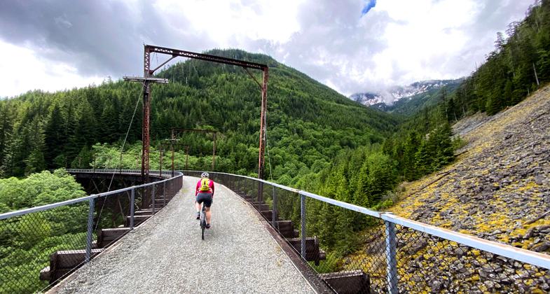
Winner 2024 NRT Photo Contest, Rail and Canal Trails. Photo by David Saxen

Rail cut in the eastern end of the Iron Horse State Park portion of the Palouse to Cascades State Park Trail. Photo by Williamborg/wiki.

One of many trestle bridges along the Palous-Cascades Trail. Photo by Hagen Hammons.

One of many trestle bridges along the Palouse-Cascades Trail. Photo by Hagen Hammons.

John Wayne Pioneer Wagons and Riders annual spring ride across Eastern Washington. Photo by Jeff Chapman.

View of Rock Lake from Palouse to Cascades State Park Trail. Photo by Williamborg/wiki.

View of Saddle Mountains from the Palouse to Cascades State Park Trail. Photo by Williamborg/wiki.
Location: Western Cascade Foothills to Ellensburg
- States: Washington
- Counties: King, Kittitas
Formally known as the John Wayne Pioneer Trail.
Eventually, visitors will be able to travel on the trail across the entire state of Washington on the gentle grade of the former Milwaukee Road right of way. With more than 100 miles of trail extending from Cedar Falls in the Cascade Mountains to the Columbia River in central Washington, the Palouse to Cascades State Park Trail is perfect for long or short trips. The trail leads travelers past high trestles with spectacular views of the valley below, mountainous terrain, sagebrush desert, arid scrublands, and charming countryside farmlands of the Columbia Basin.
The trail is open year-round so that hikers, bicyclists, equestrians, wagoners, cross-country skiers, snowshoers, and dog sledders can discover the rugged beauty of the Pacific Northwest. The family-friendly trail has a light gravel surface, a gentle and easy-to-negotiate grade, and camping along the way. Interpretive panels along the trail offer a peek into the history of the area.
Travelers also can look for the speck of light at the end of the 2.3-mile Snoqualmie Tunnel under Snoqualmie Pass - the nation's longest tunnel open to nonmotorized traffic. The Milwaukee Road built this tunnel in 1914 to improve the grade over the pass.
The trail, much of it managed by the Washington State Parks and Recreation Commission, meanders through and past a number of Washington state parks, as well as public campgrounds managed by the U.S. Forest Service and Kittitas County Fairgrounds and several other hiking trails that intersect the Palouse to Cascades State Park Trail. So, travelers can make the most of any trip by taking advantage of a number of other recreational and interpretive opportunities.
Accessibility Information
No text provided.
Allowed Uses:
Bicycling Dogs, on leash Equestrian Hiking/Walking Motorized vehicles, snowmobiling Snow, cross-country skiingOther Activities
- Camping
- Fishing
- Rock climbing
- Snow, snow play general
Public Contact
Washington State ParksLake Easton State Park
Easton, WA 98925
(509) 656-2230
www.parks.wa.gov
Contact the trail manager for current maps and visiting details.
More Details
- Elevation (low): 1517
- Elevation (high): 3022
- Elevation (cumulative): --
- Part of a Trail System? No
- National Designations: Legacy Millennium
- Surface (primary): Rock, crushed
- Surfaces (additional): Rock, crushed
- Tread Width (average): 127"
- Tread Width (minimum): --
- Running length (minimum): --
- Tread Grade (average, percent): 2
- Tread Grade (maximum): 3
- Running length (maximum): --
- Cross-slope (average, percent): --
- Cross-slope (maximum): --
- Running length (maximum): --
- Certified as an NRT
May 31, 2002

