Turkey Mountain Urban Wilderness Trails Network
check with the trail manager for updated details before visiting.
Turkey Mountain Urban Wilderness Trails Network
- Length
6.7 miles - Elevation Gain
-- - Route Type
Loop
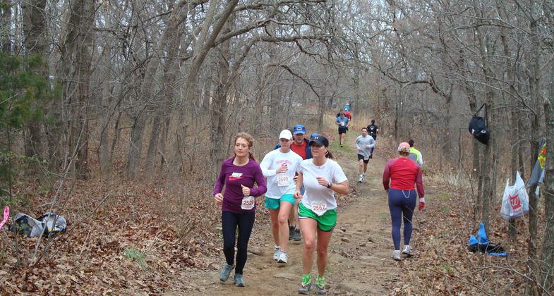
The trails at Turkey Mountain wind through more than 300 acres of wilderness. Boasting 6.7 miles of marked trails, an additional 5.7 miles slated to be improved and marked, and more than 30 miles of unmarked trails for exploration. Some trails traverse along cliffs overlooking the Arkansas River; others take you into the heart of the wilderness past ponds and rock gardens. Turkey Mountain offers beginner to advanced trails for the hiker, trail runner, mountain biker, and equestrian rider.
Location: Turkey Mountain trailhead is located at 68th and Elwood, Tulsa, OK. The 300+ acre Wilderness stretches from I-44 on the N to 71st Street on the S, on the E the Arkansas River and US highway 75 on the W. This urban treasure is less than 7 mi from downtown.
- States: Oklahoma
- Counties: Tulsa
- Cities/Townships: Tulsa
Managed by the River Parks Authority and a mere seven miles from downtown Tulsa one may find a refuge from city life on the trails of Turkey Mountain Urban Wilderness Area. It is within walking distance for many Westside residents and also easily accessible to all Tulsa residents from the River Parks paved trails on the east bank of the Arkansas River. With canopied trails crisscrossed with roots and rocks, blessed with views of the Arkansas River, and basically untouched by humanity, Turkey Mountain is an urban treasure.
The main entrance at 67th and South Elwood was recently upgraded by a $1.5 million grant from the George Kaiser Family Foundation and offer landscaped parking, restrooms, climbing boulders, a rain garden, and flagstone walkways leading to the main trailhead. A map of the marked trails, which are shared by hikers, runners, mountain bikers, and equestrians, is located near the trailhead. The parking lot can accommodate 70 vehicles in addition to designated space for equestrian trailers and handicapped. Other private contributions near the trailhead area include two NatureWorks wildlife sculptures and three multi-purpose pavilions.
The 300-plus acre wilderness stretches from I-44 to 71st Street and US 75 to the west bank of the Arkansas River. This heavily-wooded property has miles of winding primitive trails and two large ponds, features that date back long before the land was acquired for public usage. The summit of Turkey Mountain rises 300 feet above the Arkansas River and offers a panoramic view of Tulsa.
For persons considering visiting Turkey Mountain, it may not be what you would expect. When most think of Oklahoma, they think of flat land, few trees, and lots of red dirt. Turkey Mountain has the opposite. Turkey Mountain lies within the Cross Timbers ecoregion. This landform in Oklahoma served as the inspiration for the forests in Washington Irving's literary work, The Legend of Sleepy Hollow. He would later refer to them as "forests of cast iron" after his tour of the prairies in 1832. Steep hillsides combine with thick vegetation make traipsing through the woods difficult. One occasionally must dodge tree limbs and jump rocks.
For runners, this means that Turkey Mountain presents a great deal of variety. Bikers will appreciate the technical aspects, although beginners may quickly learn that their skillset may need improvement before venturing out on the more challenging trails.
These urban wilderness trails attract many visitors from out of state. References to Turkey Mountain may be found in numerous outdoor recreation and tourism publications.
Singletracks, a mountain biking publication notes"The trails at Turkey Mountain in Tulsa, OK are among the most popular in the state of Oklahoma (last year's #1, this year's #2) and for good reason: the trails are challenging and located close to where riders live."
MTBProject.com writes: "Turkey Mountain is a hidden Mountain Bike Paradise in Tulsa, Ok! Turkey has something for everyone."
The three marked trails are the Red, Yellow, and Blue trails. The trailhead for the Red Trail is south of the parking lot, with a 0.8-mile loop it is the shortest trail, and this trail is popular with beginners. The Yellow trail loop is 4.4 miles and begins at the trailhead on the north side of the parking lot; it meanders north and then east to the Vista Point offering views of downtown Tulsa and the Arkansas River. The loop continues north parallel to the river until a sharp turn returns to the trailhead. It is enjoyed by enthusiasts for its technical aspects. The Blue Trail consists of a 1.5-mile loop leading into the heart of Turkey Mountain, it has some steeper climbs and winds north past a pond to the upper parking lot which also provides an alternate beginning point. In addition to the marked trails, there are over 30 miles of unmarked trails; 5.7 miles comprise the mapped Pink trail from the upper lot leading into the scenic western half of Turkey.
Equestrians may need to stay away from some of the steeper, rockier sections. Families with children will enjoy the shorter side trails close to the parking lot, as well as the paved trails that skirt the river and connect to the River Parks' paved trail system which loops around both sides of the Arkansas River. Dogs are allowed at Turkey Mountain but must be leashed and well-behaved. The trails within Turkey Mountain Urban Wilderness have a direct connection to the Tulsa Regional Trail System, where users may access more than 80 miles of paved multi-use trails around the county. The dirt trails of Turkey Mountain are uniquely situated within the geographic west center of the Tulsa Metropolitan Area, providing an opportunity for both individuals and families to escape the hectic demands of daily urban life and be refreshed by a true wilderness experience.
Accessibility Information
No text provided.
Allowed Uses:
Bicycling Dogs, on leash Equestrian Hiking/WalkingOther Activities
- Fishing
- Heritage and history
- Wildlife viewing / observation
Public Contact
Matt MeyerRiver Parks Authority
2424 E. 21st St., Suite 300
Tulsa, OK 74114
staff@riverparks.org • (918)596-2001
Contact the trail manager for current maps and visiting details.
More Details
- Elevation (low): 607
- Elevation (high): 950
- Elevation (cumulative): --
- Part of a Trail System? No
- Surface (primary): Soil
- Surfaces (additional): Paved, Grass or Vegetation, Rock, boulders, Rock, smooth, Soil
- Tread Width (average): 30"
- Tread Width (minimum): 18
- Running length (minimum): --
- Tread Grade (average, percent): 7
- Tread Grade (maximum): 40
- Running length (maximum): --
- Cross-slope (average, percent): 4
- Cross-slope (maximum): --
- Running length (maximum): --
- Certified as an NRT
Jun 1, 2016


