Urban Wilderness South Loop Trail
check with the trail manager for updated details before visiting.
Urban Wilderness South Loop Trail
City, Town, or County
Backcountry Trail
Frontcountry Trail
Urban Trail
- Length
28.4 miles
- Elevation Gain
--
- Route Type
Loop
- Length
28.4 miles - Elevation Gain
-- - Route Type
Loop
The Urban Wilderness South Loop Trail lies within the 1,000-forested acres along Knoxville's downtown waterfront that includes ten parks, more than forty miles of recreational trails, incredible views and unparalleled natural features.

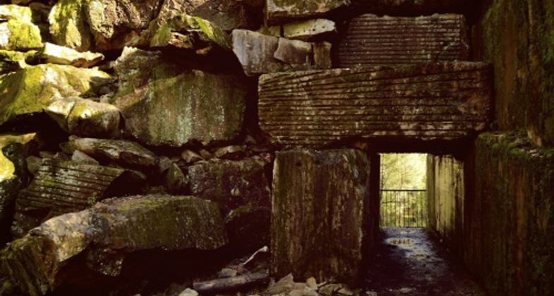
Keyhole entrance to Ross Marble Quarry at Ijams. Photo by Adventures On Earth

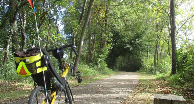
Photo by Jim Schmid.
Location: South Knoxville, a sector within the limits of the City of Knoxville
- States: Tennessee
- Counties: Knox
- Cities/Townships: City of Knoxville
Knoxville Urban Wilderness is a 42-mile trail system within the heart of a city literally two miles from Knoxville, Tennessee's downtown core. The unique urban-wilderness combination offers the advantage to trail riders of spending a day in the woods and an evening out on the town. The system is different from typical trails. Rather than a system of trails within a park, it is a system of trails that connects parks, public and private land. As such, the system offers a diversity of views, topography, and scenery. The trails traverse dramatic 30' tall rock outcroppings, remnants of an old limestone quarry, weave around a brilliantly blue quarry lake, wetlands, sink holes, rolling farmland, and sunflower fields. They climb through mature hardwood forests, and woods abundant with wildflowers, and exit surprisingly into a neighborhood through a bamboo thicket. They provide a gentle ride along the Tennessee River and through a nature center. The entire system is well signed with four trailheads with informational kiosks, maps, and directional posts throughout the system.
The Urban Wilderness South Loop Trail has landed Knoxville in several prestigious articles. Reuters cited the vibrant leaf-peeping prospects along the trail as one of the reasons Knoxville was listed as No. 5 on Reuter's Top 10 U.S. Destinations in October. The trail was also mentioned as a major Knoxville attribute in a New York Post article, "Knoxville is Jaunty." National Geographic writers have even come to scope out the Urban Wilderness South Loop Trail.
The majority of the Urban Wilderness South Loop Trail was built by the volunteer efforts of the Appalachian Mountain Bike Club. There are several noteworthy destinations along the Urban Wilderness South Loop Trail:
Ijams Nature Center
Developed by Harry Ijams, Knoxville's leading bird expert, and Alice Yoe Ijams, "First Lady of Knoxville Garden Clubs". The Ijams place has been a gathering point for birder and nature lovers for more than a century.
Girl Scouting has been a fixture at Ijams since 1923, followed by Camp Mary Ijams, and Camp Margaret Townsend in the Smokies was created in part through Ijams and Townsend family ties. Harry Ijams also helped establish the first official campsite on Mount LeConte and used his artistry as a commercial illustrator to promote the Smoky Mountains as a national park.
Ijams Nature Center is a 300-acre wildlife sanctuary that has several visitor must-sees. Located barely a mile downstream from the birth of the Tennessee River (where the Holston and French Broad rivers converge) the extensive boardwalk roughly the length of a football field has long been a visitor favorite. The boardwalk meanders along a riverside cliff, complete with a cave.
The Ross Marble Quarry at Ijams is an abandoned dry quarry that features a keyhole entrance for hikers, leaving visitors with a sense of entering a well-hidden secret. The views from the Rock Bridge above overlooking what locals call God's Chair are stunning.
The now gorgeous water of Mead's Quarry at Ijams was once the murkiest spot in all of Knox County, this important Tennessee Marble Quarry, and later illegal dump, has been transformed into a rugged post-industrial natural area with a 25-acre lake and gorgeous views. Stone from Meads was used in numerous local national buildings and monuments, including the U.S. Capitol. In the summer, visitors can catch a glimpse of freshwater jellyfish in the lake.
A short hop from the keyhole at Ross Marble Quarry, Ijams' Hayworth Hallow takes visitors along the quarry gorge's moss-covered boulders to a stunning view of sheer rock walls towering hundreds of feet above.
William Hastie Natural Area
This park, owned by the City of Knoxville, was named in honor of Knoxville native William Hastie. He was appointed as the first African-American federal judge. The natural surface trails in the William Hastie Natural Area contain a wide array of surfaces and unique challenges, providing hikers, trail runners, and mountain bikers with 4 miles of singletrack trails. Winding through the heavily forested property and circling the perimeter of the 75-acre park, the trails at times traverse across off-camber rock seams and loose shale.
Tennessee Wildlife Resources Wildlife Management Area
The trail system within the Forks of the River Wildlife Management Area combines trails created over time by wildlife and hunters with those constructed more recently by the Appalachian Mountain Bike Club. The paved City of Knoxville Will Skelton Greenway is also found within the WMA along the river boundary and connects the WMA to both Ijams Nature Center and the natural surface trails. There are multiple trails to experience within the WMA, all of varying degrees of difficulty, views, and topography. The internal trails pass through open fields, hardwood forests, and hedgerows all home to an abundance of wildlife and songbird activity. In mid-summer, visitors and birds alike enjoy acres upon acres of sunflower fields.
Accessibility Information
No text provided.
Allowed Uses:
Bicycling Dogs, on leash Hiking/WalkingOther Activities
- Fishing
- Heritage and history
- Hunting
- Wildlife viewing / observation
Public Contact
Joe WalshCity of Knoxville
400 Main St
Knoxville, TN 37902
[email protected] • (865) 215-2091
Contact the trail manager for current maps and visiting details.
More Details
- Elevation (low): 819
- Elevation (high): 1184
- Elevation (cumulative): --
- Part of a Trail System? No
- National Designations: N/A
- State Designations: N/A
- Surface (primary): Soil
- Surfaces (additional): Paved, Boardwalk, Rock, crushed, Soil
- Tread Width (average): 48"
- Tread Width (minimum): 36
- Running length (minimum): --
- Tread Grade (average, percent): 7
- Tread Grade (maximum): 40
- Running length (maximum): --
- Cross-slope (average, percent): 18
- Cross-slope (maximum): --
- Running length (maximum): --
- Certified as an NRT
Jun 2, 2014


