Volksweg Trail
check with the trail manager for updated details before visiting.
Volksweg Trail
U.S. Corps of Engineers
Backcountry Trail
Frontcountry Trail
Urban Trail
- Length
14 miles
- Elevation Gain
--
- Route Type
out & back
- Length
14 miles - Elevation Gain
-- - Route Type
out & back
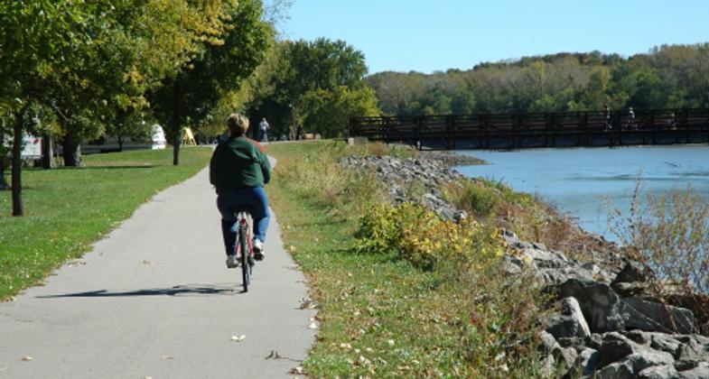
Volksweg is a Dutch word meaning"people's path," and this unique trail serves as a path connecting the picturesque city of Pella to the recreation areas of Lake Red Rock. The trail traverses timbered areas, restored prairies, pine plantations, and open fields while offering spectacular views of Lake Red Rock.
Location: This trail runs parallel to a country road from Pella to Lake Red Rock. From there, the trail follows the Des Moines River and winds through the North Overlook Woods, then continues along the north side of the lake to the Fifield Recreation Area.
- States: Iowa
- Counties: Marion
- Cities/Townships: Pella
The 14-mile Volksweg Trail traverses timbered areas, restored prairies, pine plantations, and open fields between Pella and Lake Red Rock in Marion County, Iowa. Volksweg, or "people's path", follows the Des Moines River and winds through the North Overlook Woods offering spectacular scenic views of Lake Red Rock. While most slopes on the Volksweg Trail are less than 5%, some approach 7%, allowing for a stimulating biking or jogging experience. On the trail, visitors can catch glimpses of game and non-game animals, as well as a variety of birds, including Bald Eagles throughout the year. This is a 10' wide paved trail, closed to motorized traffic and maintained through a combined effort of the Marion County Conservation Board, the city of Pella, and the Army Corp of Engineers.
The primary trailhead is located at the Public Library Trailhead in the heart of Pella, which is a city full of history and culture. Each year a festival is held, entitled,"Pella Tulip Time" to celebrate the city's Dutch heritage. Tulips serve as a much-loved symbol for the Netherlands. Many residents of Pella originally emigrated from the Netherlands, and use the festival to appreciate their roots. On average, over 100,000 people come for the festival from all around the county. From that number, many stay for what Pella has to offer, including the Volksweg Trail.
Destinations on the Volksweg trail include the Howell Station Campground at Red Rock Dam, Lion's Park, Wallashuck Recreation Area, Fifield Recreation Area, and the Red Rock Marina.
The trail features great bridges (including crossing over the Des Moines River), picnic areas, multiple trailheads, clean restrooms, and a surface suitable for families or fitness enthusiasts. Lake Red Rock is a man-made reservoir, formed by the damming of the Des Moines River for flood control in 1969. As Iowa's largest lake, Lake Red Rock offers a variety of recreational opportunities including picnicking, camping, hiking, swimming, hunting, and boating.
The acquisition and development of the Volksweg Trail was possible through a combination of private, federal, state, and county efforts, and funding by the Des Moines River Greenbelt Program.
The Volksweg Trail is a continuing project, constantly growing and improving. The eventual plan for this trail is that it will intertwine the Lake Red Rock Area including the visitor's center, and the City of Knoxville and become part of a rails-to-trails project which will travel up through Monroe and Prairie City, Iowa to connect up to the Central Iowa Trail System, which covers an expanse of eleven counties, and nearly 700 miles in central Iowa.
Accessibility Information
No text provided.
Allowed Uses:
Bicycling Boating, motorized Boating, human-powered Swimming Dogs, on leash Equestrian Hiking/Walking Snow, cross-country skiing Snow, snowshoeingOther Activities
- Camping
- Fishing
- Hunting
- Snow, snow play general
- Wildlife viewing / observation
Public Contact
Sherri DueyArmy Corps of Engineers
1105 North Highway T15
Knoxville, IA 50138
[email protected] • (641) 828-7522
Contact the trail manager for current maps and visiting details.
More Details
- Elevation (low): 704
- Elevation (high): 852
- Elevation (cumulative): --
- Part of a Trail System? No
- Surface (primary): Paved
- Surfaces (additional): --
- Tread Width (average): 120"
- Tread Width (minimum): 96
- Running length (minimum): --
- Tread Grade (average, percent): --
- Tread Grade (maximum): 7
- Running length (maximum): --
- Cross-slope (average, percent): 0
- Cross-slope (maximum): --
- Running length (maximum): --
- Certified as an NRT
May 29, 2013


