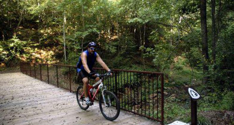
W. Kerr Scott Trails
check with the trail manager for updated details before visiting.
W. Kerr Scott Trails
U.S. Corps of Engineers
Frontcountry Trail
Urban Trail
- Length
9 miles
- Elevation Gain
--
- Route Type
out & back
- Length
9 miles - Elevation Gain
-- - Route Type
out & back
Location: W. Kerr Scott Reservoir, Fish Dam Cr. Gorge to Bandit's Roost NC Connects sites along southeast shoreline of west Scott Kerr Reservoir.
- States: North Carolina
- Counties: Wilkes
Section 1: Fish Dam Creek Gorge to Visitor's Assistance Center
During National Public Lands Day, October 8, 2005, volunteers completed a one-mile section of multi-use trail that connects the Yadkin River Greenway and Overmountain Victory National Historic Trail to the Dark Mountain National Recreational Trail System and the recreational facilities at W. Kerr Scott Reservoir. The completion of this section of the trail was the result of a collaboration between Brushy Mountain Cyclists, (local chapter of the International Bicycling Association IMBA), The U.S. Army Corps of Engineers at W. Kerr Scott Reservoir, the National Park Service, and the Yadkin River Greenway Council. The trail segment is open to the public year-round and provides a key connecting link to the area trail system, trailhead access, and trail parking facilities. The trail is maintained through a Memorandum of Understanding between the Corps of Engineers and the local IMBA chapter, Brushy Mountain Cyclists. The Fish Dam Creek Gorge trail connects the Yadkin River Greenway and the Overmountian Victory National Historic Trail. The trail's ultimate connectivity to recreational facilities at W. Kerr Scott Reservoir with facilities along the Yadkin River Greenway such as the YMCA, Wilkes Community College, and the towns of Wilkesboro and North Wilkesboro, makes the trail a tremendous recreational resource in Federal Lands managed by the U. S. Army Corps of Engineers.
Section 2 - Visitor's Assistance Center to Bandit's Roost Campground
During National Public Lands Day, October 8, 2005, volunteers completed an eight-mile section of multi-use trail that connects the Bandit's Roost Campground to the W. Kerr Scott Visitor's Center, Dark Mountain National Recreational Trail, the Yadkin River Greenway and existing designated portions of the Overmountain Victory National Historic Trail system.
The completion of this section of the trial was the result of a collaboration between Brushy Mountain Cyclists, the International Bicycling Association IMBA chapter. The U.S. Army Corps of Engineers at W. Kerr Scott Reservoir, and the National Park Service The trail segment is open to the public year-round and provides a key connecting link to the area trail system, trailhead access, and trail parking facilities. The trail is maintained through a Memorandum of Understanding between the Corps of Engineers and the local IMBA chapter. Brushy Mountain Cyclists. The Fish Dam Creek Gorge trail connects the Yadkin River Greenway and the Overmountian Victory National Historic Trail. The trail's ultimate connectivity to recreational facilities at W. Kerr Scott Reservoir with facilities along the Yadkin River Greenway such as the YMCA, Wilkes Community College, and the towns of Wilkesboro and North Wilkesboro, makes the trail a tremendous recreational resource in Federal Lands managed by the U. S. Army Corps of Engineers.
Accessibility Information
No text provided.
Allowed Uses:
Bicycling Boating, motorized Dogs, on leash Hiking/WalkingOther Activities
- Camping
- Fishing
Public Contact
Terry RamseyUS Army Corps of Engineers
499 Reservoir Road
Wilkesboro, NC 28697
[email protected] • (336) 921-3750
Contact the trail manager for current maps and visiting details.
More Details
- Elevation (low): 960
- Elevation (high): 1107
- Elevation (cumulative): --
- Part of a Trail System? No
- National Designations: National Millenium
- Surface (primary): Rock, crushed
- Surfaces (additional): Rock, crushed
- Tread Width (average): 48"
- Tread Width (minimum): --
- Running length (minimum): --
- Tread Grade (average, percent): 4
- Tread Grade (maximum): 8
- Running length (maximum): --
- Cross-slope (average, percent): --
- Cross-slope (maximum): --
- Running length (maximum): --
- Certified as an NRT
May 31, 2006


