Whiteside Mountain
check with the trail manager for updated details before visiting.
Whiteside Mountain
USDA Forest Service
Backcountry Trail
- Length
2 miles
- Elevation Gain
--
- Route Type
out & back
- Length
2 miles - Elevation Gain
-- - Route Type
out & back
Location: Whiteside Mountain is located south of U.S. 64 between Highlands and Cashiers.
- States: North Carolina
- Counties: Jackson
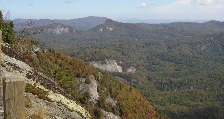
A landmark along the Eastern Continental Divide, Whiteside Mountain rises to an elevation of 4,930 feet. The mountain's cliffs look like sheets of ice draped across the mountain. This magnificent rock is about 390 to 460 million years old.
A 2-mile loop trail climbs above sheer 750-foot high cliffs and offers outstanding views to the east, south, and west. Whiteside Mountain Trail is rated more difficult because of its steepness. Along your journey to the top, you can spot a variety of wildflowers-including false Solomons seal, white snakeroot, dwarf dandelion, speckled wood-lily, and wood betony.
Accessibility Information
No text provided.
Allowed Uses:
Dogs, on leash Hiking/WalkingOther Activities
- Rock climbing
- Wildlife viewing / observation
Public Contact
Thomas SaylorsNantahala Ranger District
90 Sloan Road
Franklin, NC 28734
(828) 524-6441
www.fs.usda.gov/nfsnc
Contact the trail manager for current maps and visiting details.
More Details
- Elevation (low): --
- Elevation (high): 4930
- Elevation (cumulative): --
- Part of a Trail System? No
- Surface (primary): Soil
- Surfaces (additional): Soil
- Tread Width (average): 36"
- Tread Width (minimum): --
- Running length (minimum): --
- Tread Grade (average, percent): 12
- Tread Grade (maximum): 20
- Running length (maximum): --
- Cross-slope (average, percent): --
- Cross-slope (maximum): --
- Running length (maximum): --
- Certified as an NRT
Aug 6, 1978


