Wonderland Trail
check with the trail manager for updated details before visiting.
Wonderland Trail
National Park Service
Backcountry Trail
- Length
90 miles
- Elevation Gain
--
- Route Type
out & back
- Length
90 miles - Elevation Gain
-- - Route Type
out & back
Circuit of Mt. Rainier entirely within the park.
Location: Wraps around midslope of Mt. Rainier in Mt. Rainier National Park.
- States: Washington
- Counties: Pierce
The Circuit of Mt. Rainier is entirely within the park. Crosses numerous ridges and valleys. 8-12 days to complete. Many portions are accessible by road and can be done as day hikes.
The Wonderland Trail is a distinguishing feature of Mount Rainier National Park. The establishment of the trail took place at the turn of the century when the"Wonderland" was an attraction used to promote park visitation. Later, rangers used the trail as a patrol beat. Original ranger cabins are still in use. The oldest cabin, constructed in 1915, is at Indian Henry's Hunting Ground.
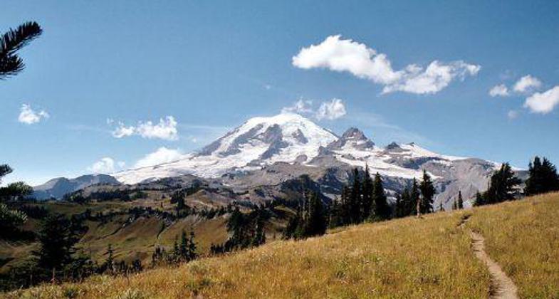
Today's hikers find the 93-mile Wonderland to be one of the best ways to explore Mount Rainier National Park. The trail passes through major life zones of the park, from lowland forests to sub-alpine meadows of wildflowers. Passing swift rivers, the trail leads to commanding views of Mount Rainier cloaked in icy glaciers. As the trail circles the mountain, hikers witness the varied faces of Mount Rainier, carved by 25 named glaciers.
Weather is a constantly changing factor. While summer is often dry and sunny, oceanic influences can also bring moisture as rain or snow at higher elevations. Hikers can find both company and solitude along the way. Although thousands hike the Wonderland Trail each summer, many stretches of the trail still provide the chance to be alone. Prior awareness of trail and weather conditions, wilderness regulations, and general hiking information about the park will enhance a trip along the Wonderland Trail.
Accessibility Information
No text provided.
Allowed Uses:
Equestrian Hiking/WalkingPublic Contact
Carl FabianiMount Rainier National Park
Tahoma Woods
Ashford, WA 98304
[email protected] • (360) 569-2211 ext. 3
Contact the trail manager for current maps and visiting details.
More Details
- Elevation (low): --
- Elevation (high): --
- Elevation (cumulative): --
- Part of a Trail System? No
- Surface (primary): Soil
- Surfaces (additional): --
- Tread Width (average): 36"
- Tread Width (minimum): --
- Running length (minimum): --
- Tread Grade (average, percent): --
- Tread Grade (maximum):
- Running length (maximum): --
- Cross-slope (average, percent): --
- Cross-slope (maximum): --
- Running length (maximum): --
- Certified as an NRT
Mar 19, 1981


